Barras elevation
Barras (Piauí), Brazil elevation is 89 meters and Barras elevation in feet is 292 ft above sea level [src 1]. Barras is a populated place (feature code) with elevation that is 293 meters (961 ft) smaller than average city elevation in Brazil.
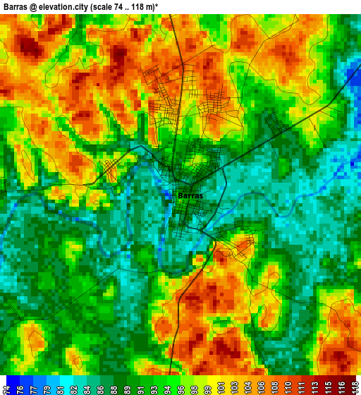
Below is the Elevation map of Barras, which displays elevation range with different colors. Scale of the first map is from 74 to 118 m (243 to 387 ft) with average elevation of 94.9 meters (=311 ft) [note 1]
These maps also provides idea of topography and contour of this city, they are displayed at different zoom levels. More info about maps, scale and edge coordinates you can find below images.
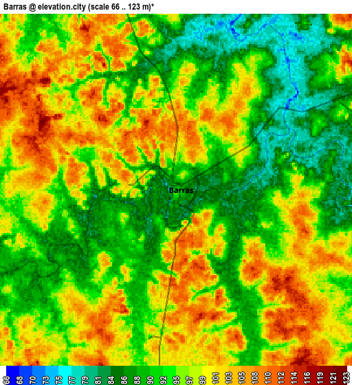
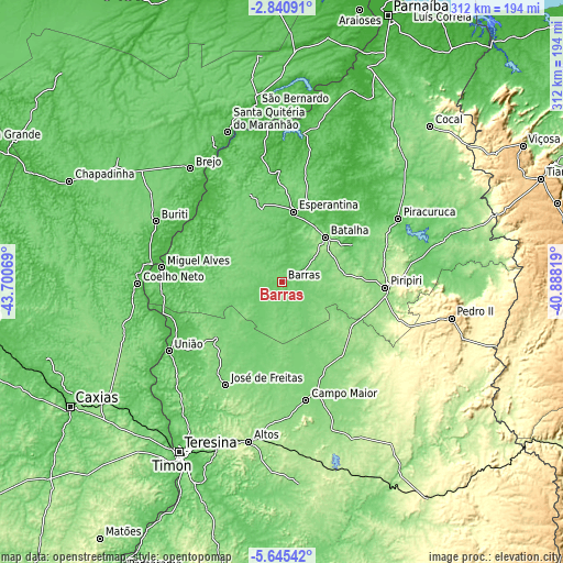
| \ | Map #1 | Map #2 | Topo.Map |
| Scale [m] | 74..118 m | 66..123 m | × |
| Scale [ft] | 243..387 ft | 217..404 ft | × |
| Average | 94.9 m = 311 ft | 95.5 m = 313 ft | × |
| Width | 9.75 km = 6.1 mi | 19.49 km = 12.1 mi | 311.8 km = 193.7 mi |
| Height | 9.75 km = 6.1 mi | 19.49 km = 12.1 mi | 311.9 km = 193.8 mi |
| ↑Max Latitude | -4.200614° | -4.156785° | -2.84091° |
| Latitude at center | -4.24444° | -4.24444° | -4.24444° |
| ↓Min Latitude | -4.288264° | -4.332085° | -5.64542° |
| ← Min Longitude | -42.338385° | -42.382331° | -43.70069° |
| Longitude center | -42.29444° | -42.29444° | -42.29444° |
| →Max Longitude | -42.250495° | -42.206549° | -40.88819° |
Nearby cities:
Cities around Barras sort by population:
• Piripiri elevation 164 m
57.5 km,  93°
93°
• Coelho Neto 54 m
79.7 km,  269°
269°
• Campo Maior 128 m
66.3 km,  167°
167°
• José de Freitas 131 m
64.9 km,  208°
208°
• Esperantina 63 m
38.7 km,  10°
10°
• Piracuruca 75 m
73.8 km,  61°
61°
• União 60 m
73.7 km,  238°
238°
• Brejo 70 m
80.2 km,  320°
320°
• Miguel Alves 46 m
67.2 km,  277°
277°
• Batalha 119 m
34.5 km,  44°
44°
• Porto 40 m
60.4 km,  310°
310°
• Matias Olímpio 71 m
65.5 km,  333°
333°
Multilingual:
 En español:
Barras elevación 89 m.
 En France:
Barras élévation 89 m.


Sources and notes:
- [note 1] Map square and city borders are not equal. Map elevation data is calculated only from area inside that square.
- [src 1] Elevation data from geonames database provided with same terms of usage.
- [src 2] The elevation map of Barras is generated using elevation data from NASA's 3 arcsec (90m) resolution SRTM data.
- [src 3] Base (background) map © OpenStreetMap contributors tiles are generated by Geofabrik and OpenTopoMap.
Copyright & License:
This Barras Elevation Map is licensed under CC BY-SA. You may reuse any part from this page, if you give a proper credit by linking to this URL:
 More info on terms of use page.