Matias Olímpio elevation
Matias Olímpio (Piauí), Brazil elevation is 71 meters and Matias Olímpio elevation in feet is 233 ft above sea level [src 1]. Matias Olímpio is a populated place (feature code) with elevation that is 311 meters (1020 ft) smaller than average city elevation in Brazil.
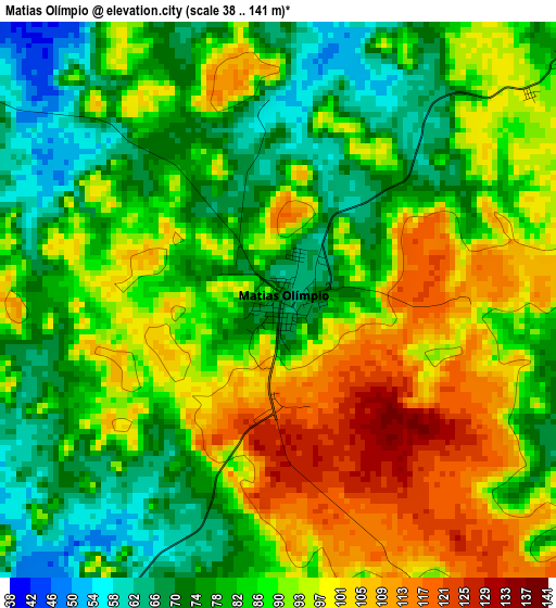
Below is the Elevation map of Matias Olímpio, which displays elevation range with different colors. Scale of the first map is from 38 to 141 m (125 to 463 ft) with average elevation of 87.3 meters (=286 ft) [note 1]
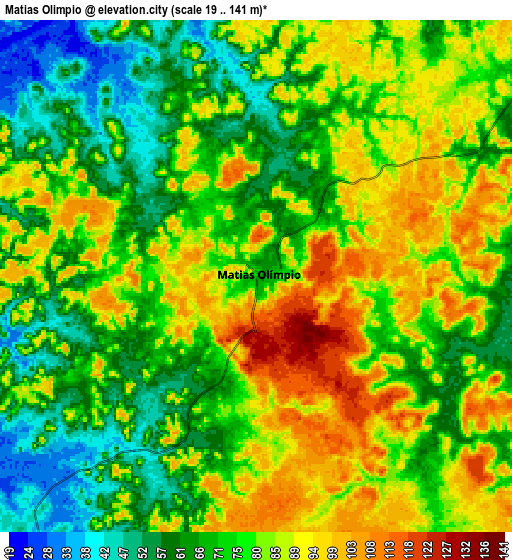
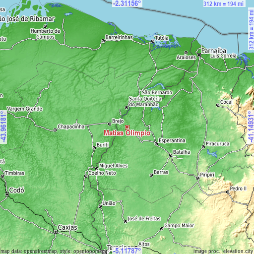
These maps also provides idea of topography and contour of this city, they are displayed at different zoom levels. More info about maps, scale and edge coordinates you can find below images.
| \ | Map #1 | Map #2 | Topo.Map |
| Scale [m] | 38..141 m | 19..141 m | × |
| Scale [ft] | 125..463 ft | 62..463 ft | × |
| Average | 87.3 m = 286 ft | 77.4 m = 254 ft | × |
| Width | 9.75 km = 6.1 mi | 19.5 km = 12.1 mi | 312 km = 193.9 mi |
| Height | 9.75 km = 6.1 mi | 19.5 km = 12.1 mi | 312.1 km = 193.9 mi |
| ↑Max Latitude | -3.671976° | -3.62812° | -2.31156° |
| Latitude at center | -3.71583° | -3.71583° | -3.71583° |
| ↓Min Latitude | -3.759682° | -3.803531° | -5.11787° |
| ← Min Longitude | -42.599505° | -42.643451° | -43.96181° |
| Longitude center | -42.55556° | -42.55556° | -42.55556° |
| →Max Longitude | -42.511615° | -42.467669° | -41.14931° |
Nearby cities:
Cities around Matias Olímpio sort by population:
• Chapadinha elevation 109 m
89.3 km,  268°
268°
• Coelho Neto 54 m
78.7 km,  220°
220°
• Barras 89 m
65.5 km,  153°
153°
• Esperantina 63 m
41.3 km,  120°
120°
• Piracuruca 75 m
96.8 km,  104°
104°
• Santa Quitéria do Maranhão 29 m
22.3 km,  2°
2°
• Luzilândia 39 m
35.3 km,  35°
35°
• Brejo 70 m
21.9 km,  279°
279°
• São Bernardo 29 m
42.3 km,  21°
21°
• Miguel Alves 46 m
62.6 km, 217°
• Batalha 119 m
63.4 km, 122°
• Porto 40 m
26.1 km, 220°
Multilingual:
 En español:
Matias Olímpio elevación 71 m.
 En France:
Matias Olímpio élévation 71 m.
 Auf Deutsch:
Matias Olímpio höhe über dem Meeresspiegel ist 71 m.

Sources and notes:
- [note 1] Map square and city borders are not equal. Map elevation data is calculated only from area inside that square.
- [src 1] Elevation data from geonames database provided with same terms of usage.
- [src 2] The elevation map of Matias Olímpio is generated using elevation data from NASA's 3 arcsec (90m) resolution SRTM data.
- [src 3] Base (background) map © OpenStreetMap contributors tiles are generated by Geofabrik and OpenTopoMap.
Copyright & License:
This Matias Olímpio Elevation Map is licensed under CC BY-SA. You may reuse any part from this page, if you give a proper credit by linking to this URL:
 More info on terms of use page.