Piracuruca elevation
Piracuruca (Piauí), Brazil elevation is 75 meters and Piracuruca elevation in feet is 246 ft above sea level [src 1]. Piracuruca is a populated place (feature code) with elevation that is 307 meters (1007 ft) smaller than average city elevation in Brazil.
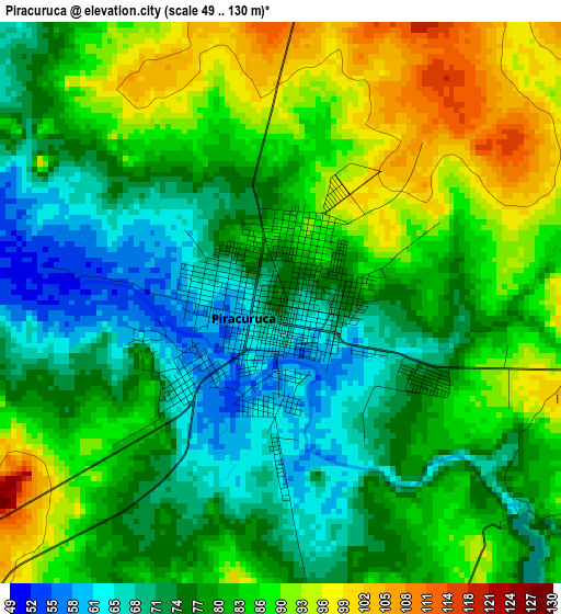
Below is the Elevation map of Piracuruca, which displays elevation range with different colors. Scale of the first map is from 49 to 130 m (161 to 427 ft) with average elevation of 80.6 meters (=264 ft) [note 1]
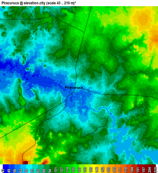
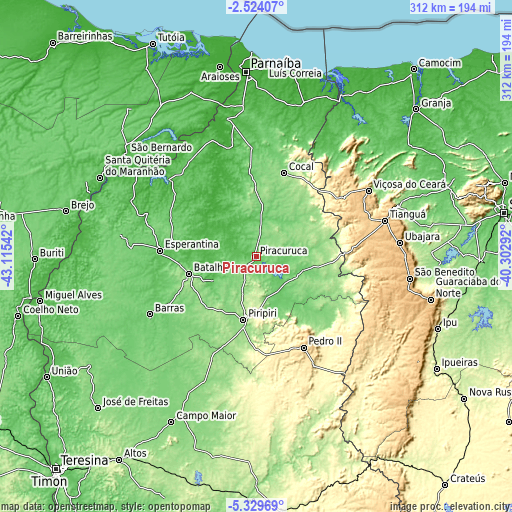
These maps also provides idea of topography and contour of this city, they are displayed at different zoom levels. More info about maps, scale and edge coordinates you can find below images.
| \ | Map #1 | Map #2 | Topo.Map |
| Scale [m] | 49..130 m | 43..210 m | × |
| Scale [ft] | 161..427 ft | 141..689 ft | × |
| Average | 80.6 m = 264 ft | 97.3 m = 319 ft | × |
| Width | 9.75 km = 6.1 mi | 19.5 km = 12.1 mi | 312 km = 193.9 mi |
| Height | 9.75 km = 6.1 mi | 19.5 km = 12.1 mi | 312 km = 193.9 mi |
| ↑Max Latitude | -3.884217° | -3.840371° | -2.52407° |
| Latitude at center | -3.92806° | -3.92806° | -3.92806° |
| ↓Min Latitude | -3.971901° | -4.01574° | -5.32969° |
| ← Min Longitude | -41.753115° | -41.797061° | -43.11542° |
| Longitude center | -41.70917° | -41.70917° | -41.70917° |
| →Max Longitude | -41.665225° | -41.621279° | -40.30292° |
Nearby cities:
Cities around Piracuruca sort by population:
• Tianguá elevation 773 m
82.5 km,  74°
74°
• Piripiri 164 m
39.1 km,  191°
191°
• Pedro II 608 m
61.8 km,  153°
153°
• Barras 89 m
73.8 km,  241°
241°
• Esperantina 63 m
58.3 km,  272°
272°
• Viçosa do Ceará 719 m
79.6 km,  59°
59°
• Ubajara 855 m
87.8 km,  84°
84°
• Luzilândia 39 m
90.1 km,  305°
305°
• Cocal 129 m
53.4 km,  18°
18°
• Buriti dos Lopes 23 m
85.5 km,  348°
348°
• Batalha 119 m
42 km,  255°
255°
• Juá dos Vieiras 516 m
63.1 km,  45°
45°
Multilingual:
 En español:
Piracuruca elevación 75 m.
 En France:
Piracuruca élévation 75 m.
 Auf Deutsch:
Piracuruca höhe über dem Meeresspiegel ist 75 m.

Sources and notes:
- [note 1] Map square and city borders are not equal. Map elevation data is calculated only from area inside that square.
- [src 1] Elevation data from geonames database provided with same terms of usage.
- [src 2] The elevation map of Piracuruca is generated using elevation data from NASA's 3 arcsec (90m) resolution SRTM data.
- [src 3] Base (background) map © OpenStreetMap contributors tiles are generated by Geofabrik and OpenTopoMap.
Copyright & License:
This Piracuruca Elevation Map is licensed under CC BY-SA. You may reuse any part from this page, if you give a proper credit by linking to this URL:
 More info on terms of use page.