Victoria Falls elevation
Victoria Falls (Matabeleland North, Hwange District), Zimbabwe elevation is 961 meters and Victoria Falls elevation in feet is 3153 ft above sea level [src 1]. Victoria Falls is a populated place (feature code) with elevation that is 239 meters (784 ft) smaller than average city elevation in Zimbabwe.
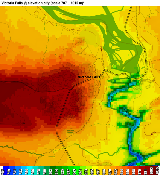
Below is the Elevation map of Victoria Falls, which displays elevation range with different colors. Scale of the first map is from 707 to 1015 m (2320 to 3330 ft) with average elevation of 918.2 meters (=3012 ft) [note 1]
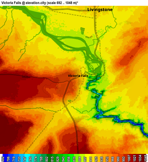
These maps also provides idea of topography and contour of this city, they are displayed at different zoom levels. More info about maps, scale and edge coordinates you can find below images.
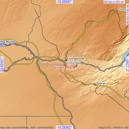
| \ | Map #1 | Map #2 | Topo.Map |
| Scale [m] | 707..1015 m | 692..1048 m | × |
| Scale [ft] | 2320..3330 ft | 2270..3438 ft | × |
| Average | 918.2 m = 3012 ft | 934.3 m = 3065 ft | × |
| Width | 9.3 km = 5.8 mi | 18.6 km = 11.6 mi | 297.5 km = 184.9 mi |
| Height | 9.3 km = 5.8 mi | 18.6 km = 11.6 mi | 297.5 km = 184.9 mi |
| ↑Max Latitude | -17.891035° | -17.84921° | -16.58997° |
| Latitude at center | -17.93285° | -17.93285° | -17.93285° |
| ↓Min Latitude | -17.974655° | -18.016451° | -19.26562° |
| ← Min Longitude | 25.786715° | 25.742769° | 24.42441° |
| Longitude center | 25.83066° | 25.83066° | 25.83066° |
| →Max Longitude | 25.874605° | 25.918551° | 27.23691° |
Nearby cities:
Cities around Victoria Falls sort by population:
• Bulawayo elevation 1348 m
380.1 km,  130°
130°
• Hwange 767 m
85.4 km,  124°
124°
• Kariba 679 m
352.5 km,  63°
63°
• Gokwe 1237 m
329.5 km,  95°
95°
• Inyati 1333 m
371.9 km, 121°
• Binga 628 m
163.7 km,  77°
77°
• Dete 1112 m
133.2 km, 124°
• Insiza 1422 m
409.9 km, 120°
• Plumtree 1384 m
352 km,  143°
143°
• Chirundu 402 m
384.3 km, 56°
• Kamativi Mine 953 m
136.4 km,  108°
108°
• Lupane 1016 m
236.2 km, 118°
Multilingual:
 En español:
Victoria Falls elevación 961 m.
 En France:
Chutes Victoria élévation 961 m.
 Auf Deutsch:
Victoria Falls höhe über dem Meeresspiegel ist 961 m.

Sources and notes:
- [note 1] Map square and city borders are not equal. Map elevation data is calculated only from area inside that square.
- [src 1] Elevation data from geonames database provided with same terms of usage.
- [src 2] The elevation map of Victoria Falls is generated using elevation data from NASA's 3 arcsec (90m) resolution SRTM data.
- [src 3] Base (background) map © OpenStreetMap contributors tiles are generated by Geofabrik and OpenTopoMap.
Copyright & License:
This Victoria Falls Elevation Map is licensed under CC BY-SA. You may reuse any part from this page, if you give a proper credit by linking to this URL:
 More info on terms of use page.