Inyati elevation
Inyati (Matabeleland North), Zimbabwe elevation is 1333 meters and Inyati elevation in feet is 4373 ft above sea level [src 1]. Inyati is a populated place (feature code) with elevation that is 133 meters (436 ft) bigger than average city elevation in Zimbabwe.
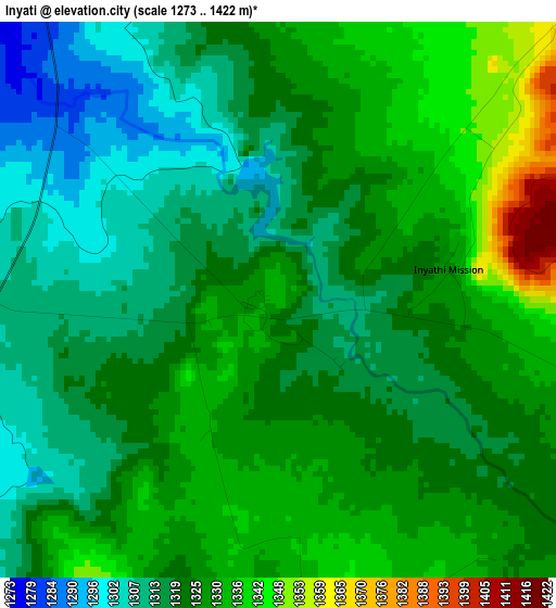
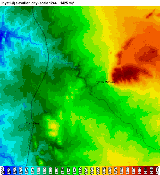
Below is the Elevation map of Inyati, which displays elevation range with different colors. Scale of the first map is from 1273 to 1422 m (4177 to 4665 ft) with average elevation of 1323 meters (=4341 ft) [note 1]
These maps also provides idea of topography and contour of this city, they are displayed at different zoom levels. More info about maps, scale and edge coordinates you can find below images.
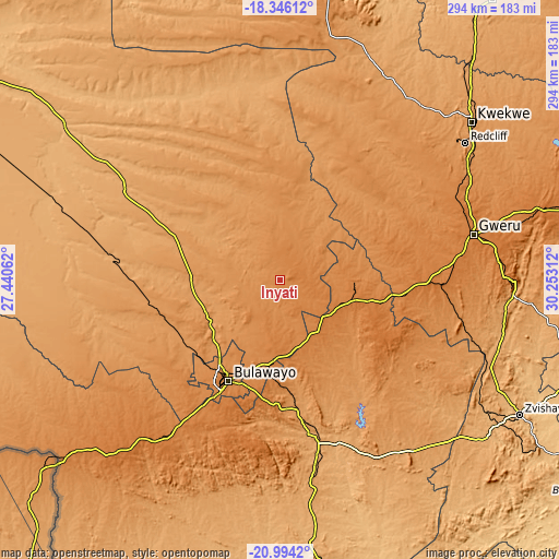
| \ | Map #1 | Map #2 | Topo.Map |
| Scale [m] | 1273..1422 m | 1244..1425 m | × |
| Scale [ft] | 4177..4665 ft | 4081..4675 ft | × |
| Average | 1323 m = 4341 ft | 1324.5 m = 4345 ft | × |
| Width | 9.2 km = 5.7 mi | 18.4 km = 11.4 mi | 294.4 km = 182.9 mi |
| Height | 9.2 km = 5.7 mi | 18.4 km = 11.4 mi | 294.5 km = 183 mi |
| ↑Max Latitude | -19.634245° | -19.59285° | -18.34612° |
| Latitude at center | -19.67563° | -19.67563° | -19.67563° |
| ↓Min Latitude | -19.717004° | -19.758368° | -20.9942° |
| ← Min Longitude | 28.802925° | 28.758979° | 27.44062° |
| Longitude center | 28.84687° | 28.84687° | 28.84687° |
| →Max Longitude | 28.890815° | 28.934761° | 30.25312° |
Nearby cities:
Cities around Inyati sort by population:
• Bulawayo elevation 1348 m
59.5 km,  207°
207°
• Gweru 1412 m
104.7 km,  76°
76°
• Kwekwe 1203 m
131.3 km,  50°
50°
• Redcliff 1232 m
121.5 km, 53°
• Shurugwi 1483 m
121.4 km,  89°
89°
• Gwanda 966 m
141.2 km,  173°
173°
• Shangani 1377 m
55.7 km,  102°
102°
• Insiza 1422 m
38.9 km,  107°
107°
• Esigodini 1181 m
68.7 km, 173°
• Plumtree 1384 m
140.1 km,  230°
230°
• Filabusi 1072 m
105.8 km,  154°
154°
• Lupane 1016 m
136.9 km,  307°
307°
Multilingual:
 En español:
Inyati elevación 1333 m.
 En France:
Inyati élévation 1333 m.


Sources and notes:
- [note 1] Map square and city borders are not equal. Map elevation data is calculated only from area inside that square.
- [src 1] Elevation data from geonames database provided with same terms of usage.
- [src 2] The elevation map of Inyati is generated using elevation data from NASA's 3 arcsec (90m) resolution SRTM data.
- [src 3] Base (background) map © OpenStreetMap contributors tiles are generated by Geofabrik and OpenTopoMap.
Copyright & License:
This Inyati Elevation Map is licensed under CC BY-SA. You may reuse any part from this page, if you give a proper credit by linking to this URL:
 More info on terms of use page.