Bulawayo elevation
Bulawayo, Zimbabwe elevation is 1348 meters and Bulawayo elevation in feet is 4423 ft above sea level [src 1]. Bulawayo is a seat of a first-order administrative division (feature code) with elevation that is 148 meters (486 ft) bigger than average city elevation in Zimbabwe.
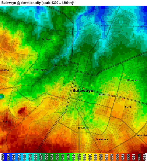
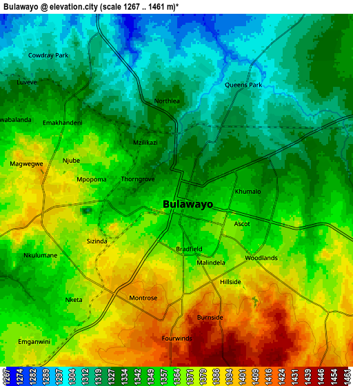
Below is the Elevation map of Bulawayo, which displays elevation range with different colors. Scale of the first map is from 1300 to 1399 m (4265 to 4590 ft) with average elevation of 1349 meters (=4426 ft) [note 1]
These maps also provides idea of topography and contour of this city, they are displayed at different zoom levels. More info about maps, scale and edge coordinates you can find below images.
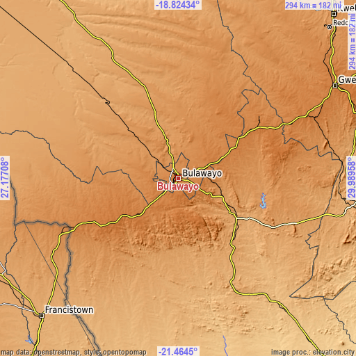
| \ | Map #1 | Map #2 | Topo.Map |
| Scale [m] | 1300..1399 m | 1267..1461 m | × |
| Scale [ft] | 4265..4590 ft | 4157..4793 ft | × |
| Average | 1349 m = 4426 ft | 1352.4 m = 4437 ft | × |
| Width | 9.17 km = 5.7 mi | 18.35 km = 11.4 mi | 293.6 km = 182.4 mi |
| Height | 9.17 km = 5.7 mi | 18.35 km = 11.4 mi | 293.6 km = 182.4 mi |
| ↑Max Latitude | -20.108739° | -20.067467° | -18.82434° |
| Latitude at center | -20.15° | -20.15° | -20.15° |
| ↓Min Latitude | -20.19125° | -20.232489° | -21.4645° |
| ← Min Longitude | 28.539385° | 28.495439° | 27.17708° |
| Longitude center | 28.58333° | 28.58333° | 28.58333° |
| →Max Longitude | 28.627275° | 28.671221° | 29.98958° |
Nearby cities:
Cities around Bulawayo sort by population:
• Gweru elevation 1412 m
150.7 km,  58°
58°
• Zvishavane 998 m
156 km,  97°
97°
• Redcliff 1232 m
176.7 km,  45°
45°
• Shurugwi 1483 m
158 km,  70°
70°
• Gwanda 966 m
97.9 km,  153°
153°
• Inyati 1333 m
59.5 km,  27°
27°
• Shangani 1377 m
91.5 km, 63°
• Insiza 1422 m
76.3 km, 57°
• Esigodini 1181 m
38.7 km,  113°
113°
• Plumtree 1384 m
88.1 km,  245°
245°
• Filabusi 1072 m
84.7 km,  120°
120°
• Lupane 1016 m
158 km,  329°
329°
Multilingual:
 En español:
Bulawayo elevación 1348 m.
 En France:
Bulawayo élévation 1348 m.
 Auf Deutsch:
Bulawayo höhe über dem Meeresspiegel ist 1348 m.

Sources and notes:
- [note 1] Map square and city borders are not equal. Map elevation data is calculated only from area inside that square.
- [src 1] Elevation data from geonames database provided with same terms of usage.
- [src 2] The elevation map of Bulawayo is generated using elevation data from NASA's 3 arcsec (90m) resolution SRTM data.
- [src 3] Base (background) map © OpenStreetMap contributors tiles are generated by Geofabrik and OpenTopoMap.
Copyright & License:
This Bulawayo Elevation Map is licensed under CC BY-SA. You may reuse any part from this page, if you give a proper credit by linking to this URL:
 More info on terms of use page.