Kariba elevation
Kariba (Mashonaland West), Zimbabwe elevation is 679 meters and Kariba elevation in feet is 2228 ft above sea level [src 1]. Kariba is a populated place (feature code) with elevation that is 521 meters (1709 ft) smaller than average city elevation in Zimbabwe.
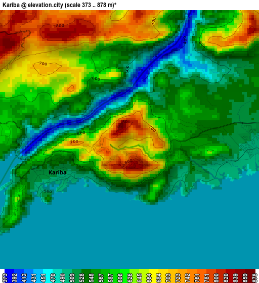
Below is the Elevation map of Kariba, which displays elevation range with different colors. Scale of the first map is from 373 to 878 m (1224 to 2881 ft) with average elevation of 562.7 meters (=1846 ft) [note 1]
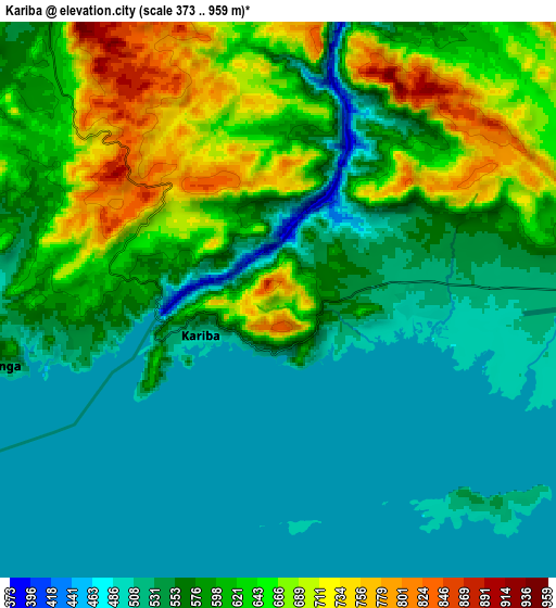
These maps also provides idea of topography and contour of this city, they are displayed at different zoom levels. More info about maps, scale and edge coordinates you can find below images.
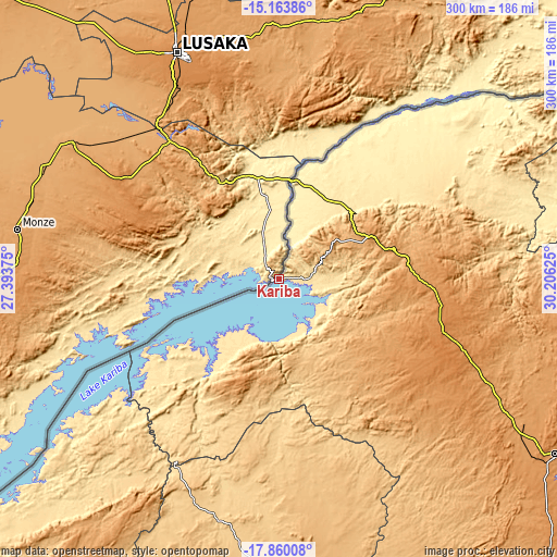
| \ | Map #1 | Map #2 | Topo.Map |
| Scale [m] | 373..878 m | 373..959 m | × |
| Scale [ft] | 1224..2881 ft | 1224..3146 ft | × |
| Average | 562.7 m = 1846 ft | 577.9 m = 1896 ft | × |
| Width | 9.37 km = 5.8 mi | 18.74 km = 11.6 mi | 299.8 km = 186.3 mi |
| Height | 9.37 km = 5.8 mi | 18.74 km = 11.6 mi | 299.8 km = 186.3 mi |
| ↑Max Latitude | -16.474533° | -16.432388° | -15.16386° |
| Latitude at center | -16.51667° | -16.51667° | -16.51667° |
| ↓Min Latitude | -16.558797° | -16.600916° | -17.86008° |
| ← Min Longitude | 28.756055° | 28.712109° | 27.39375° |
| Longitude center | 28.8° | 28.8° | 28.8° |
| →Max Longitude | 28.843945° | 28.887891° | 30.20625° |
Nearby cities:
Cities around Kariba sort by population:
• Kadoma elevation 1176 m
234.1 km,  149°
149°
• Chinhoyi 1153 m
176.4 km,  122°
122°
• Chegutu 1187 m
229 km,  141°
141°
• Karoi 1259 m
100.5 km,  108°
108°
• Gokwe 1237 m
188.2 km,  175°
175°
• Banket 1277 m
195.6 km, 119°
• Mvurwi 1495 m
225.7 km,  104°
104°
• Mhangura 1182 m
151.6 km, 106°
• Chakari 1107 m
207.4 km, 145°
• Binga 628 m
197.7 km,  231°
231°
• Raffingora 1160 m
183.1 km, 108°
• Chirundu 402 m
54 km,  5°
5°
Multilingual:
 En español:
Kariba elevación 679 m.
 En France:
Kariba élévation 679 m.


Sources and notes:
- [note 1] Map square and city borders are not equal. Map elevation data is calculated only from area inside that square.
- [src 1] Elevation data from geonames database provided with same terms of usage.
- [src 2] The elevation map of Kariba is generated using elevation data from NASA's 3 arcsec (90m) resolution SRTM data.
- [src 3] Base (background) map © OpenStreetMap contributors tiles are generated by Geofabrik and OpenTopoMap.
Copyright & License:
This Kariba Elevation Map is licensed under CC BY-SA. You may reuse any part from this page, if you give a proper credit by linking to this URL:
 More info on terms of use page.