Chegutu elevation
Chegutu (Mashonaland West), Zimbabwe elevation is 1187 meters and Chegutu elevation in feet is 3894 ft above sea level [src 1]. Chegutu is a populated place (feature code) with elevation that is 13 meters (43 ft) smaller than average city elevation in Zimbabwe.
Below is the Elevation map of Chegutu, which displays elevation range with different colors. Scale of the first map is from 1151 to 1211 m (3776 to 3973 ft) with average elevation of 1181.8 meters (=3877 ft) [note 1]
These maps also provides idea of topography and contour of this city, they are displayed at different zoom levels. More info about maps, scale and edge coordinates you can find below images.
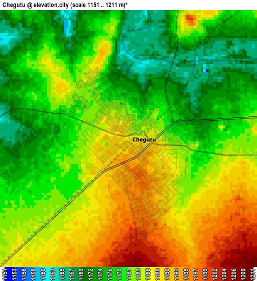
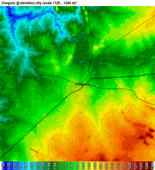
| \ | Map #1 | Map #2 | Topo.Map |
| Scale [m] | 1151..1211 m | 1128..1244 m | × |
| Scale [ft] | 3776..3973 ft | 3701..4081 ft | × |
| Average | 1181.8 m = 3877 ft | 1182.7 m = 3880 ft | × |
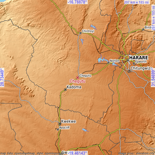
| Width | 9.29 km = 5.8 mi | 18.57 km = 11.5 mi | 297.2 km = 184.7 mi |
| Height | 9.29 km = 5.8 mi | 18.57 km = 11.5 mi | 297.2 km = 184.7 mi |
| ↑Max Latitude | -18.088442° | -18.046663° | -16.78878° |
| Latitude at center | -18.13021° | -18.13021° | -18.13021° |
| ↓Min Latitude | -18.171969° | -18.213717° | -19.46143° |
| ← Min Longitude | 30.096795° | 30.052849° | 28.73449° |
| Longitude center | 30.14074° | 30.14074° | 30.14074° |
| →Max Longitude | 30.184685° | 30.228631° | 31.54699° |
Nearby cities:
Cities around Chegutu sort by population:
• Harare elevation 1494 m
102.2 km,  70°
70°
• Chitungwiza 1435 m
99.7 km,  82°
82°
• Epworth 1508 m
109.8 km, 75°
• Kwekwe 1203 m
95.1 km,  201°
201°
• Kadoma 1176 m
32.8 km,  226°
226°
• Chinhoyi 1153 m
85.1 km,  4°
4°
• Norton 1364 m
65.2 km, 65°
• Redcliff 1232 m
107.3 km, 200°
• Mazowe 1249 m
112.4 km,  51°
51°
• Banket 1277 m
87.5 km,  18°
18°
• Chakari 1107 m
27.3 km,  285°
285°
• Beatrice 1307 m
75.9 km,  100°
100°
Multilingual:
 En español:
Chegutu elevación 1187 m.
 En France:
Chegutu élévation 1187 m.
 Auf Deutsch:
Chegutu höhe über dem Meeresspiegel ist 1187 m.

Sources and notes:
- [note 1] Map square and city borders are not equal. Map elevation data is calculated only from area inside that square.
- [src 1] Elevation data from geonames database provided with same terms of usage.
- [src 2] The elevation map of Chegutu is generated using elevation data from NASA's 3 arcsec (90m) resolution SRTM data.
- [src 3] Base (background) map © OpenStreetMap contributors tiles are generated by Geofabrik and OpenTopoMap.
Copyright & License:
This Chegutu Elevation Map is licensed under CC BY-SA. You may reuse any part from this page, if you give a proper credit by linking to this URL:
 More info on terms of use page.