Mhangura elevation
Mhangura (Mashonaland West), Zimbabwe elevation is 1182 meters and Mhangura elevation in feet is 3878 ft above sea level [src 1]. Mhangura is a populated place (feature code) with elevation that is 18 meters (59 ft) smaller than average city elevation in Zimbabwe.
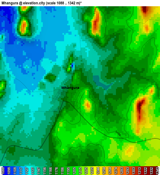
Below is the Elevation map of Mhangura, which displays elevation range with different colors. Scale of the first map is from 1088 to 1342 m (3570 to 4403 ft) with average elevation of 1172.6 meters (=3847 ft) [note 1]
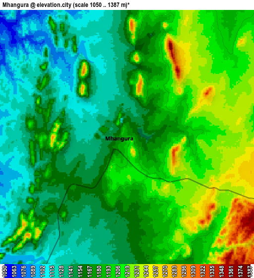
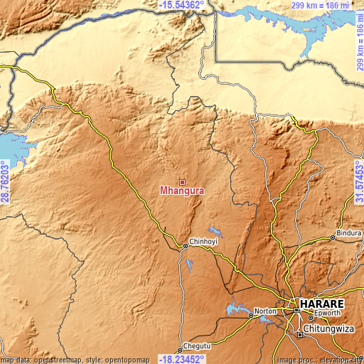
These maps also provides idea of topography and contour of this city, they are displayed at different zoom levels. More info about maps, scale and edge coordinates you can find below images.
| \ | Map #1 | Map #2 | Topo.Map |
| Scale [m] | 1088..1342 m | 1050..1387 m | × |
| Scale [ft] | 3570..4403 ft | 3445..4551 ft | × |
| Average | 1172.6 m = 3847 ft | 1175.6 m = 3857 ft | × |
| Width | 9.35 km = 5.8 mi | 18.7 km = 11.6 mi | 299.2 km = 185.9 mi |
| Height | 9.35 km = 5.8 mi | 18.7 km = 11.6 mi | 299.2 km = 185.9 mi |
| ↑Max Latitude | -16.851816° | -16.809754° | -15.54362° |
| Latitude at center | -16.89387° | -16.89387° | -16.89387° |
| ↓Min Latitude | -16.935914° | -16.977949° | -18.23452° |
| ← Min Longitude | 30.124335° | 30.080389° | 28.76203° |
| Longitude center | 30.16828° | 30.16828° | 30.16828° |
| →Max Longitude | 30.212225° | 30.256171° | 31.57453° |
Nearby cities:
Cities around Mhangura sort by population:
• Chinhoyi elevation 1153 m
52.7 km,  176°
176°
• Norton 1364 m
123.6 km,  152°
152°
• Bindura 1118 m
131.6 km,  110°
110°
• Karoi 1259 m
51.5 km,  280°
280°
• Mazowe 1249 m
109.2 km,  128°
128°
• Glendale 1143 m
108.4 km,  118°
118°
• Banket 1277 m
59.7 km,  155°
155°
• Mvurwi 1495 m
74.1 km,  102°
102°
• Chakari 1107 m
133.2 km,  192°
192°
• Concession 1331 m
99.3 km, 123°
• Centenary 1186 m
102.5 km,  79°
79°
• Raffingora 1160 m
32.2 km, 118°
Multilingual:
 En español:
Mhangura elevación 1182 m.
 En France:
Mhangura élévation 1182 m.
 Auf Deutsch:
Mhangura höhe über dem Meeresspiegel ist 1182 m.

Sources and notes:
- [note 1] Map square and city borders are not equal. Map elevation data is calculated only from area inside that square.
- [src 1] Elevation data from geonames database provided with same terms of usage.
- [src 2] The elevation map of Mhangura is generated using elevation data from NASA's 3 arcsec (90m) resolution SRTM data.
- [src 3] Base (background) map © OpenStreetMap contributors tiles are generated by Geofabrik and OpenTopoMap.
Copyright & License:
This Mhangura Elevation Map is licensed under CC BY-SA. You may reuse any part from this page, if you give a proper credit by linking to this URL:
 More info on terms of use page.