Gokwe elevation
Gokwe (Midlands), Zimbabwe elevation is 1237 meters and Gokwe elevation in feet is 4058 ft above sea level [src 1]. Gokwe is a populated place (feature code) with elevation that is 37 meters (121 ft) bigger than average city elevation in Zimbabwe.
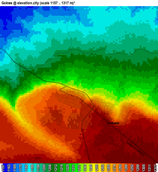
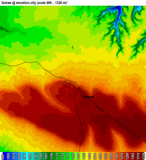
Below is the Elevation map of Gokwe, which displays elevation range with different colors. Scale of the first map is from 1157 to 1317 m (3796 to 4321 ft) with average elevation of 1239.4 meters (=4066 ft) [note 1]
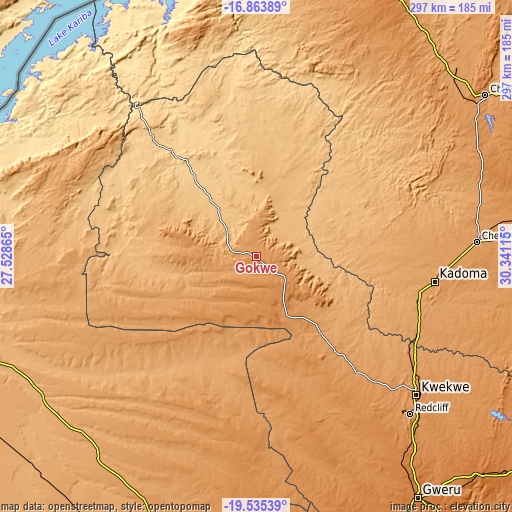
These maps also provides idea of topography and contour of this city, they are displayed at different zoom levels. More info about maps, scale and edge coordinates you can find below images.
| \ | Map #1 | Map #2 | Topo.Map |
| Scale [m] | 1157..1317 m | 989..1328 m | × |
| Scale [ft] | 3796..4321 ft | 3245..4357 ft | × |
| Average | 1239.4 m = 4066 ft | 1220.5 m = 4004 ft | × |
| Width | 9.28 km = 5.8 mi | 18.57 km = 11.5 mi | 297 km = 184.5 mi |
| Height | 9.28 km = 5.8 mi | 18.57 km = 11.5 mi | 297.1 km = 184.6 mi |
| ↑Max Latitude | -18.163009° | -18.121249° | -16.86389° |
| Latitude at center | -18.20476° | -18.20476° | -18.20476° |
| ↓Min Latitude | -18.246501° | -18.288231° | -19.53539° |
| ← Min Longitude | 28.890955° | 28.847009° | 27.52865° |
| Longitude center | 28.9349° | 28.9349° | 28.9349° |
| →Max Longitude | 28.978845° | 29.022791° | 30.34115° |
Nearby cities:
Cities around Gokwe sort by population:
• Gweru elevation 1412 m
166.7 km,  146°
146°
• Kwekwe 1203 m
122.8 km,  130°
130°
• Kadoma 1176 m
104.5 km,  97°
97°
• Chinhoyi 1153 m
163.2 km,  55°
55°
• Chegutu 1187 m
127.7 km,  86°
86°
• Redcliff 1232 m
128.4 km,  135°
135°
• Karoi 1259 m
174.7 km,  27°
27°
• Banket 1277 m
180 km, 59°
• Inyati 1333 m
163.8 km,  183°
183°
• Chakari 1107 m
102.4 km,  81°
81°
• Insiza 1422 m
177.7 km,  170°
170°
• Lupane 1016 m
143.7 km,  235°
235°
Multilingual:
 En español:
Gokwe elevación 1237 m.
 En France:
Gokwe élévation 1237 m.


Sources and notes:
- [note 1] Map square and city borders are not equal. Map elevation data is calculated only from area inside that square.
- [src 1] Elevation data from geonames database provided with same terms of usage.
- [src 2] The elevation map of Gokwe is generated using elevation data from NASA's 3 arcsec (90m) resolution SRTM data.
- [src 3] Base (background) map © OpenStreetMap contributors tiles are generated by Geofabrik and OpenTopoMap.
Copyright & License:
This Gokwe Elevation Map is licensed under CC BY-SA. You may reuse any part from this page, if you give a proper credit by linking to this URL:
 More info on terms of use page.