Tinaquillo elevation
Tinaquillo (Cojedes, Municipio Falcón), Venezuela elevation is 429 meters and Tinaquillo elevation in feet is 1407 ft above sea level [src 1]. Tinaquillo is a seat of a second-order administrative division (feature code) with elevation that is 48 meters (157 ft) bigger than average city elevation in Venezuela.
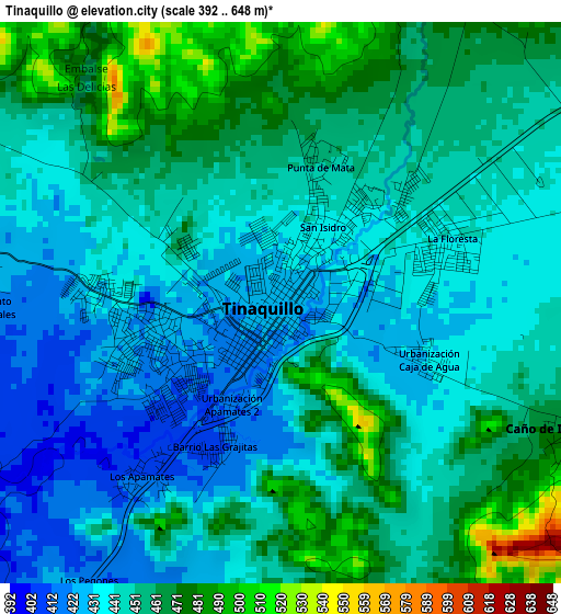
Below is the Elevation map of Tinaquillo, which displays elevation range with different colors. Scale of the first map is from 392 to 648 m (1286 to 2126 ft) with average elevation of 449.8 meters (=1476 ft) [note 1]
These maps also provides idea of topography and contour of this city, they are displayed at different zoom levels. More info about maps, scale and edge coordinates you can find below images.
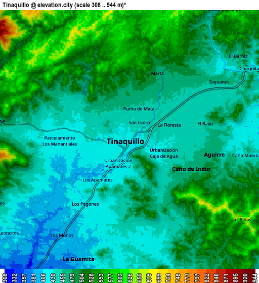
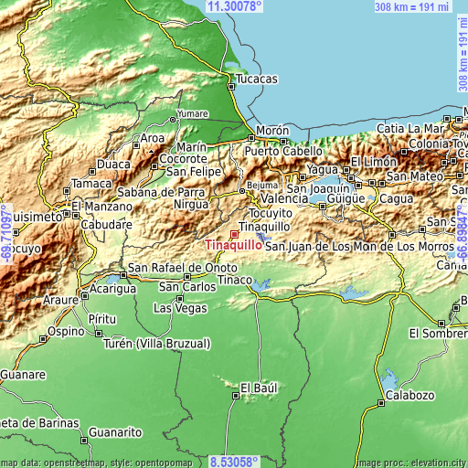
| \ | Map #1 | Map #2 | Topo.Map |
| Scale [m] | 392..648 m | 308..944 m | × |
| Scale [ft] | 1286..2126 ft | 1010..3097 ft | × |
| Average | 449.8 m = 1476 ft | 481.1 m = 1578 ft | × |
| Width | 9.63 km = 6 mi | 19.25 km = 12 mi | 308 km = 191.4 mi |
| Height | 9.63 km = 6 mi | 19.25 km = 12 mi | 308 km = 191.4 mi |
| ↑Max Latitude | 9.961896° | 10.005175° | 11.30078° |
| Latitude at center | 9.91861° | 9.91861° | 9.91861° |
| ↓Min Latitude | 9.875319° | 9.832022° | 8.53058° |
| ← Min Longitude | -68.348665° | -68.392611° | -69.71097° |
| Longitude center | -68.30472° | -68.30472° | -68.30472° |
| →Max Longitude | -68.260775° | -68.216829° | -66.89847° |
Nearby cities:
Cities around Tinaquillo sort by population:
• Valencia elevation 457 m
42.3 km,  50°
50°
• San Carlos 156 m
41.8 km,  226°
226°
• Tacarigua 427 m
46.1 km,  66°
66°
• Nirgua 874 m
38.4 km,  312°
312°
• Naguanagua 585 m
49 km,  40°
40°
• El Pao 136 m
36.5 km,  148°
148°
• Tocuyito 538 m
33.8 km, 50°
• Montalbán 669 m
32.8 km,  355°
355°
• Bejuma 675 m
28.8 km,  10°
10°
• Tinaco 156 m
28.2 km,  209°
209°
• Miranda 851 m
27.6 km,  339°
339°
• Macapo 310 m
18 km, 234°
Multilingual:
 En español:
Tinaquillo elevación 429 m.
 En France:
Tinaquillo élévation 429 m.
 Auf Deutsch:
Tinaquillo höhe über dem Meeresspiegel ist 429 m.

Sources and notes:
- [note 1] Map square and city borders are not equal. Map elevation data is calculated only from area inside that square.
- [src 1] Elevation data from geonames database provided with same terms of usage.
- [src 2] The elevation map of Tinaquillo is generated using elevation data from NASA's 3 arcsec (90m) resolution SRTM data.
- [src 3] Base (background) map © OpenStreetMap contributors tiles are generated by Geofabrik and OpenTopoMap.
Copyright & License:
This Tinaquillo Elevation Map is licensed under CC BY-SA. You may reuse any part from this page, if you give a proper credit by linking to this URL:
 More info on terms of use page.