San Carlos elevation
San Carlos (Cojedes, Municipio San Carlos), Venezuela elevation is 156 meters and San Carlos elevation in feet is 512 ft above sea level [src 1]. San Carlos is a seat of a first-order administrative division (feature code) with elevation that is 225 meters (738 ft) smaller than average city elevation in Venezuela.
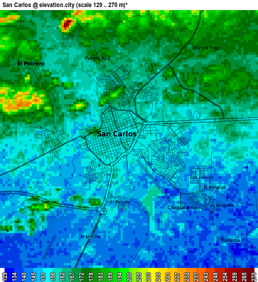
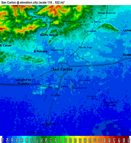
Below is the Elevation map of San Carlos, which displays elevation range with different colors. Scale of the first map is from 129 to 270 m (423 to 886 ft) with average elevation of 159.7 meters (=524 ft) [note 1]
These maps also provides idea of topography and contour of this city, they are displayed at different zoom levels. More info about maps, scale and edge coordinates you can find below images.
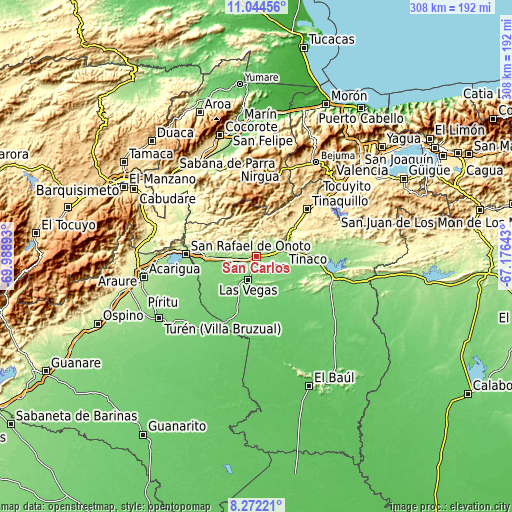
| \ | Map #1 | Map #2 | Topo.Map |
| Scale [m] | 129..270 m | 118..522 m | × |
| Scale [ft] | 423..886 ft | 387..1713 ft | × |
| Average | 159.7 m = 524 ft | 174.9 m = 574 ft | × |
| Width | 9.63 km = 6 mi | 19.27 km = 12 mi | 308.3 km = 191.6 mi |
| Height | 9.63 km = 6 mi | 19.27 km = 12 mi | 308.3 km = 191.6 mi |
| ↑Max Latitude | 9.704559° | 9.747873° | 11.04456° |
| Latitude at center | 9.66124° | 9.66124° | 9.66124° |
| ↓Min Latitude | 9.617915° | 9.574585° | 8.27221° |
| ← Min Longitude | -68.626625° | -68.670571° | -69.98893° |
| Longitude center | -68.58268° | -68.58268° | -68.58268° |
| →Max Longitude | -68.538735° | -68.494789° | -67.17643° |
Nearby cities:
Cities around San Carlos sort by population:
• Tinaquillo elevation 429 m
41.8 km,  46°
46°
• Nirgua 874 m
54.4 km,  2°
2°
• Sarare 269 m
65 km,  281°
281°
• Miranda 851 m
58.3 km,  20°
20°
• Agua Blanca 218 m
57.4 km,  270°
270°
• El Pao 136 m
49.8 km,  92°
92°
• San Rafael de Onoto 152 m
42.8 km, 272°
• Cojedes 147 m
37 km,  263°
263°
• Libertad 83 m
35.9 km,  199°
199°
• Macapo 310 m
24.1 km,  40°
40°
• Tinaco 156 m
17 km,  75°
75°
• Las Vegas 120 m
14.7 km, 200°
Multilingual:
 En español:
San Carlos elevación 156 m.
 En France:
San Carlos élévation 156 m.
 Auf Deutsch:
San Carlos höhe über dem Meeresspiegel ist 156 m.

Sources and notes:
- [note 1] Map square and city borders are not equal. Map elevation data is calculated only from area inside that square.
- [src 1] Elevation data from geonames database provided with same terms of usage.
- [src 2] The elevation map of San Carlos is generated using elevation data from NASA's 3 arcsec (90m) resolution SRTM data.
- [src 3] Base (background) map © OpenStreetMap contributors tiles are generated by Geofabrik and OpenTopoMap.
Copyright & License:
This San Carlos Elevation Map is licensed under CC BY-SA. You may reuse any part from this page, if you give a proper credit by linking to this URL:
 More info on terms of use page.