Nirgua elevation
Nirgua (Yaracuy, Municipio Nirgua), Venezuela elevation is 874 meters and Nirgua elevation in feet is 2867 ft above sea level [src 1]. Nirgua is a seat of a second-order administrative division (feature code) with elevation that is 493 meters (1617 ft) bigger than average city elevation in Venezuela.
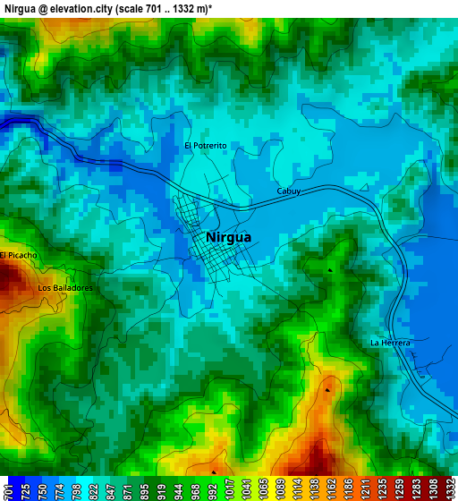
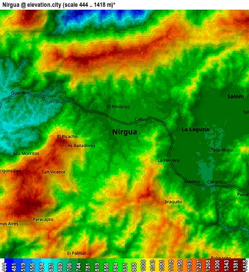
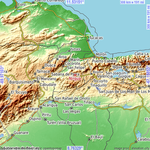
Below is the Elevation map of Nirgua, which displays elevation range with different colors. Scale of the first map is from 701 to 1332 m (2300 to 4370 ft) with average elevation of 883.9 meters (=2900 ft) [note 1]
These maps also provides idea of topography and contour of this city, they are displayed at different zoom levels. More info about maps, scale and edge coordinates you can find below images.
| \ | Map #1 | Map #2 | Topo.Map |
| Scale [m] | 701..1332 m | 444..1418 m | × |
| Scale [ft] | 2300..4370 ft | 1457..4652 ft | × |
| Average | 883.9 m = 2900 ft | 925.9 m = 3038 ft | × |
| Width | 9.62 km = 6 mi | 19.24 km = 12 mi | 307.8 km = 191.3 mi |
| Height | 9.62 km = 6 mi | 19.24 km = 12 mi | 307.8 km = 191.3 mi |
| ↑Max Latitude | 10.193645° | 10.236893° | 11.53151° |
| Latitude at center | 10.15039° | 10.15039° | 10.15039° |
| ↓Min Latitude | 10.10713° | 10.063863° | 8.76329° |
| ← Min Longitude | -68.608725° | -68.652671° | -69.97103° |
| Longitude center | -68.56478° | -68.56478° | -68.56478° |
| →Max Longitude | -68.520835° | -68.476889° | -67.15853° |
Nearby cities:
Cities around Nirgua sort by population:
• Tinaquillo elevation 429 m
38.4 km,  132°
132°
• San Felipe 287 m
28.7 km,  317°
317°
• Chivacoa 305 m
36.1 km,  271°
271°
• Farriar 40 m
35.6 km,  1°
1°
• Bejuma 675 m
33.6 km,  85°
85°
• San Pablo 312 m
32.5 km,  289°
289°
• Guama 328 m
30.7 km, 294°
• Cocorote 419 m
30.4 km,  308°
308°
• Independencia 335 m
29.2 km, 314°
• Montalbán 669 m
27 km,  75°
75°
• Boraure 188 m
24.9 km,  295°
295°
• Miranda 851 m
18.8 km, 89°
Multilingual:
 En español:
Nirgua elevación 874 m.
 En France:
Nirgua élévation 874 m.


Sources and notes:
- [note 1] Map square and city borders are not equal. Map elevation data is calculated only from area inside that square.
- [src 1] Elevation data from geonames database provided with same terms of usage.
- [src 2] The elevation map of Nirgua is generated using elevation data from NASA's 3 arcsec (90m) resolution SRTM data.
- [src 3] Base (background) map © OpenStreetMap contributors tiles are generated by Geofabrik and OpenTopoMap.
Copyright & License:
This Nirgua Elevation Map is licensed under CC BY-SA. You may reuse any part from this page, if you give a proper credit by linking to this URL:
 More info on terms of use page.