Bejuma elevation
Bejuma (Carabobo, Municipio Bejuma), Venezuela elevation is 675 meters and Bejuma elevation in feet is 2215 ft above sea level [src 1]. Bejuma is a seat of a second-order administrative division (feature code) with elevation that is 294 meters (965 ft) bigger than average city elevation in Venezuela.
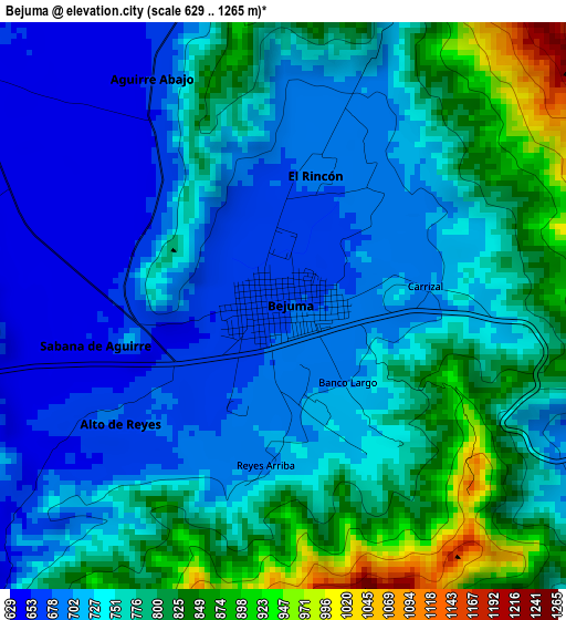
Below is the Elevation map of Bejuma, which displays elevation range with different colors. Scale of the first map is from 629 to 1265 m (2064 to 4150 ft) with average elevation of 751.8 meters (=2467 ft) [note 1]
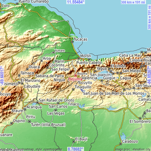
These maps also provides idea of topography and contour of this city, they are displayed at different zoom levels. More info about maps, scale and edge coordinates you can find below images.
| \ | Map #1 | Topo.Map |
| Scale [m] | 629..1265 m | × |
| Scale [ft] | 2064..4150 ft | × |
| Average | 751.8 m = 2467 ft | × |
| Width | 9.62 km = 6 mi | 307.8 km = 191.3 mi |
| Height | 9.62 km = 6 mi | 307.8 km = 191.3 mi |
| ↑Max Latitude | 10.217081° | 11.55484° |
| Latitude at center | 10.17383° | 10.17383° |
| ↓Min Latitude | 10.130573° | 8.78682° |
| ← Min Longitude | -68.302865° | -69.66517° |
| Longitude center | -68.25892° | -68.25892° |
| →Max Longitude | -68.214975° | -66.85267° |
Nearby cities:
Cities around Bejuma sort by population:
• Valencia elevation 457 m
27.5 km,  92°
92°
• Guacara 442 m
42.2 km,  82°
82°
• Tinaquillo 429 m
28.8 km,  190°
190°
• Morón 19 m
35.4 km,  10°
10°
• Tacarigua 427 m
38.4 km,  104°
104°
• Nirgua 874 m
33.6 km,  265°
265°
• Los Guayos 544 m
35.1 km, 87°
• San Diego 471 m
34.8 km,  73°
73°
• Naguanagua 585 m
28.1 km, 70°
• Tocuyito 538 m
22 km,  107°
107°
• Miranda 851 m
14.9 km,  260°
260°
• Montalbán 669 m
8.6 km,  300°
300°
Multilingual:
 En español:
Bejuma elevación 675 m.
 En France:
Bejuma élévation 675 m.


Sources and notes:
- [note 1] Map square and city borders are not equal. Map elevation data is calculated only from area inside that square.
- [src 1] Elevation data from geonames database provided with same terms of usage.
- [src 2] The elevation map of Bejuma is generated using elevation data from NASA's 3 arcsec (90m) resolution SRTM data.
- [src 3] Base (background) map © OpenStreetMap contributors tiles are generated by Geofabrik and OpenTopoMap.
Copyright & License:
This Bejuma Elevation Map is licensed under CC BY-SA. You may reuse any part from this page, if you give a proper credit by linking to this URL:
 More info on terms of use page.