Valencia elevation
Valencia (Carabobo, Municipio Valencia), Venezuela elevation is 457 meters and Valencia elevation in feet is 1499 ft above sea level [src 1]. Valencia is a seat of a first-order administrative division (feature code) with elevation that is 76 meters (249 ft) bigger than average city elevation in Venezuela.
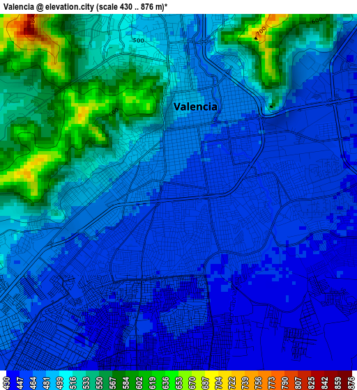
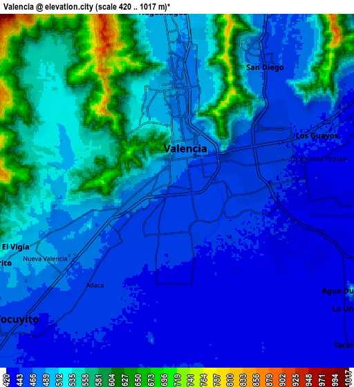
Below is the Elevation map of Valencia, which displays elevation range with different colors. Scale of the first map is from 430 to 876 m (1411 to 2874 ft) with average elevation of 490.5 meters (=1609 ft) [note 1]
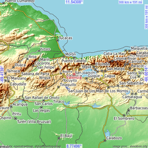
These maps also provides idea of topography and contour of this city, they are displayed at different zoom levels. More info about maps, scale and edge coordinates you can find below images.
| \ | Map #1 | Map #2 | Topo.Map |
| Scale [m] | 430..876 m | 420..1017 m | × |
| Scale [ft] | 1411..2874 ft | 1378..3337 ft | × |
| Average | 490.5 m = 1609 ft | 500.4 m = 1642 ft | × |
| Width | 9.62 km = 6 mi | 19.24 km = 12 mi | 307.8 km = 191.3 mi |
| Height | 9.62 km = 6 mi | 19.24 km = 12 mi | 307.8 km = 191.3 mi |
| ↑Max Latitude | 10.205273° | 10.24852° | 11.54308° |
| Latitude at center | 10.16202° | 10.16202° | 10.16202° |
| ↓Min Latitude | 10.118761° | 10.075496° | 8.77496° |
| ← Min Longitude | -68.051595° | -68.095541° | -69.4139° |
| Longitude center | -68.00765° | -68.00765° | -68.00765° |
| →Max Longitude | -67.963705° | -67.919759° | -66.6014° |
Nearby cities:
Cities around Valencia sort by population:
• Puerto Cabello elevation 49 m
34.6 km,  359°
359°
• Guacara 442 m
16 km,  63°
63°
• Mariara 582 m
35 km, 64°
• Güigüe 590 m
26.6 km,  109°
109°
• San Joaquín 533 m
25.9 km, 64°
• Tacarigua 427 m
12.8 km,  131°
131°
• Montalbán 669 m
35.4 km,  279°
279°
• Bejuma 675 m
27.5 km,  272°
272°
• San Diego 471 m
12.5 km,  28°
28°
• Naguanagua 585 m
10.5 km,  354°
354°
• Tocuyito 538 m
8.5 km,  230°
230°
• Los Guayos 544 m
8.2 km,  68°
68°
Multilingual:
 En español:
Valencia elevación 457 m.
 En France:
Valencia élévation 457 m.
 Auf Deutsch:
Valencia höhe über dem Meeresspiegel ist 457 m.

Sources and notes:
- [note 1] Map square and city borders are not equal. Map elevation data is calculated only from area inside that square.
- [src 1] Elevation data from geonames database provided with same terms of usage.
- [src 2] The elevation map of Valencia is generated using elevation data from NASA's 3 arcsec (90m) resolution SRTM data.
- [src 3] Base (background) map © OpenStreetMap contributors tiles are generated by Geofabrik and OpenTopoMap.
Copyright & License:
This Valencia Elevation Map is licensed under CC BY-SA. You may reuse any part from this page, if you give a proper credit by linking to this URL:
 More info on terms of use page.