Tacarigua elevation
Tacarigua (Carabobo), Venezuela elevation is 427 meters and Tacarigua elevation in feet is 1401 ft above sea level [src 1]. Tacarigua is a populated place (feature code) with elevation that is 46 meters (151 ft) bigger than average city elevation in Venezuela.
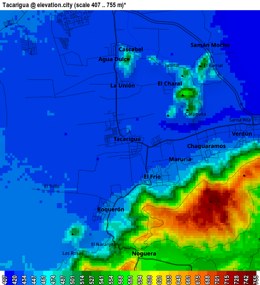
Below is the Elevation map of Tacarigua, which displays elevation range with different colors. Scale of the first map is from 407 to 755 m (1335 to 2477 ft) with average elevation of 467.2 meters (=1533 ft) [note 1]
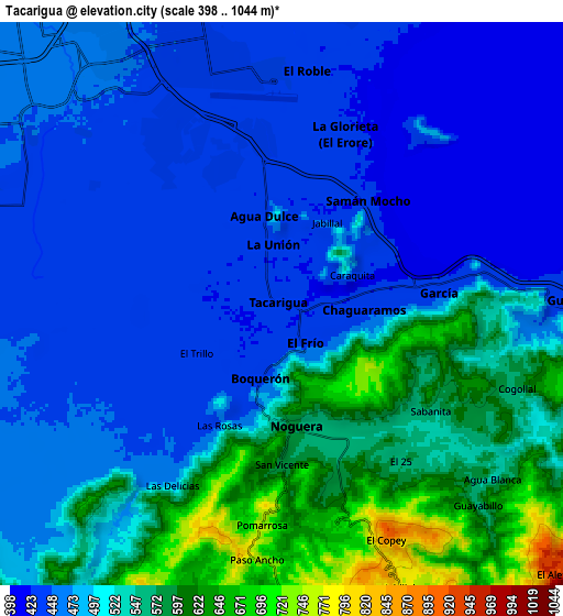
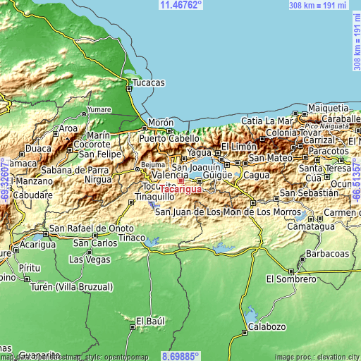
These maps also provides idea of topography and contour of this city, they are displayed at different zoom levels. More info about maps, scale and edge coordinates you can find below images.
| \ | Map #1 | Map #2 | Topo.Map |
| Scale [m] | 407..755 m | 398..1044 m | × |
| Scale [ft] | 1335..2477 ft | 1306..3425 ft | × |
| Average | 467.2 m = 1533 ft | 499 m = 1637 ft | × |
| Width | 9.62 km = 6 mi | 19.24 km = 12 mi | 307.9 km = 191.3 mi |
| Height | 9.62 km = 6 mi | 19.24 km = 12 mi | 307.9 km = 191.3 mi |
| ↑Max Latitude | 10.129473° | 10.172731° | 11.46762° |
| Latitude at center | 10.08621° | 10.08621° | 10.08621° |
| ↓Min Latitude | 10.042941° | 9.999666° | 8.69885° |
| ← Min Longitude | -67.963765° | -68.007711° | -69.32607° |
| Longitude center | -67.91982° | -67.91982° | -67.91982° |
| →Max Longitude | -67.875875° | -67.831929° | -66.51357° |
Nearby cities:
Cities around Tacarigua sort by population:
• Maracay elevation 443 m
39.6 km,  65°
65°
• Valencia 457 m
12.8 km,  311°
311°
• Guacara 442 m
16.2 km,  16°
16°
• El Limón 492 m
39.8 km,  52°
52°
• Mariara 582 m
32.1 km,  43°
43°
• Güigüe 590 m
15.5 km,  91°
91°
• San Joaquín 533 m
23.8 km, 35°
• Bejuma 675 m
38.4 km,  284°
284°
• Naguanagua 585 m
21.6 km,  330°
330°
• San Diego 471 m
19.7 km,  349°
349°
• Tocuyito 538 m
16.5 km, 280°
• Los Guayos 544 m
11.6 km, 350°
Multilingual:
 En español:
Tacarigua elevación 427 m.
 En France:
Tacarigua élévation 427 m.
 Auf Deutsch:
Tacarigua höhe über dem Meeresspiegel ist 427 m.

Sources and notes:
- [note 1] Map square and city borders are not equal. Map elevation data is calculated only from area inside that square.
- [src 1] Elevation data from geonames database provided with same terms of usage.
- [src 2] The elevation map of Tacarigua is generated using elevation data from NASA's 3 arcsec (90m) resolution SRTM data.
- [src 3] Base (background) map © OpenStreetMap contributors tiles are generated by Geofabrik and OpenTopoMap.
Copyright & License:
This Tacarigua Elevation Map is licensed under CC BY-SA. You may reuse any part from this page, if you give a proper credit by linking to this URL:
 More info on terms of use page.