El Limón elevation
El Limón (Aragua, Municipio Mario Briceño Iragorry), Venezuela elevation is 492 meters and El Limón elevation in feet is 1614 ft above sea level [src 1]. El Limón is a seat of a second-order administrative division (feature code) with elevation that is 111 meters (364 ft) bigger than average city elevation in Venezuela.
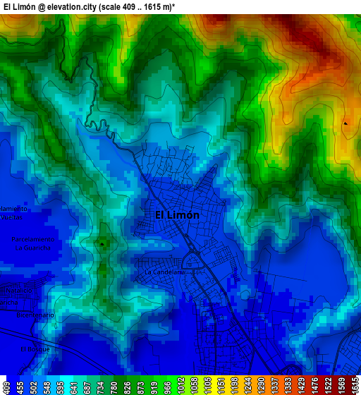
Below is the Elevation map of El Limón, which displays elevation range with different colors. Scale of the first map is from 409 to 1615 m (1342 to 5299 ft) with average elevation of 688 meters (=2257 ft) [note 1]
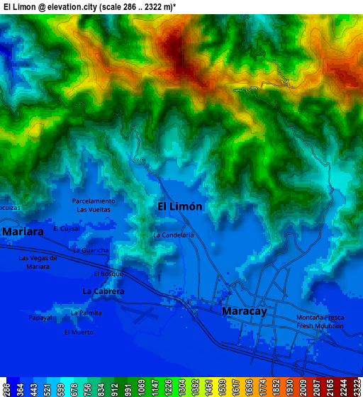
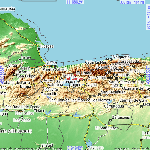
These maps also provides idea of topography and contour of this city, they are displayed at different zoom levels. More info about maps, scale and edge coordinates you can find below images.
| \ | Map #1 | Map #2 | Topo.Map |
| Scale [m] | 409..1615 m | 286..2322 m | × |
| Scale [ft] | 1342..5299 ft | 938..7618 ft | × |
| Average | 688 m = 2257 ft | 790.7 m = 2594 ft | × |
| Width | 9.61 km = 6 mi | 19.23 km = 11.9 mi | 307.6 km = 191.1 mi |
| Height | 9.61 km = 6 mi | 19.23 km = 11.9 mi | 307.7 km = 191.2 mi |
| ↑Max Latitude | 10.349123° | 10.392351° | 11.68629° |
| Latitude at center | 10.30589° | 10.30589° | 10.30589° |
| ↓Min Latitude | 10.262651° | 10.219406° | 8.91942° |
| ← Min Longitude | -67.676065° | -67.720011° | -69.03837° |
| Longitude center | -67.63212° | -67.63212° | -67.63212° |
| →Max Longitude | -67.588175° | -67.544229° | -66.22587° |
Nearby cities:
Cities around El Limón sort by population:
• Maracay elevation 443 m
9 km,  150°
150°
• Turmero 475 m
19.3 km,  116°
116°
• Guacara 442 m
28.2 km,  251°
251°
• Palo Negro 437 m
17.7 km, 146°
• Cagua 465 m
23.1 km,  125°
125°
• Mariara 582 m
9.4 km,  262°
262°
• Güigüe 590 m
29.4 km,  212°
212°
• San Mateo 497 m
25 km,  114°
114°
• San Joaquín 533 m
18.4 km, 254°
• Ocumare de la Costa 15 m
22.8 km,  319°
319°
• Santa Cruz 450 m
19.2 km,  136°
136°
• Santa Rita 581 m
13.7 km, 144°
Multilingual:
 En español:
El Limón elevación 492 m.
 En France:
El Limón élévation 492 m.
 Auf Deutsch:
El Limón höhe über dem Meeresspiegel ist 492 m.

Sources and notes:
- [note 1] Map square and city borders are not equal. Map elevation data is calculated only from area inside that square.
- [src 1] Elevation data from geonames database provided with same terms of usage.
- [src 2] The elevation map of El Limón is generated using elevation data from NASA's 3 arcsec (90m) resolution SRTM data.
- [src 3] Base (background) map © OpenStreetMap contributors tiles are generated by Geofabrik and OpenTopoMap.
Copyright & License:
This El Limón Elevation Map is licensed under CC BY-SA. You may reuse any part from this page, if you give a proper credit by linking to this URL:
 More info on terms of use page.