Palo Negro elevation
Palo Negro (Aragua, Municipio Libertador), Venezuela elevation is 437 meters and Palo Negro elevation in feet is 1434 ft above sea level [src 1]. Palo Negro is a seat of a second-order administrative division (feature code) with elevation that is 56 meters (184 ft) bigger than average city elevation in Venezuela.
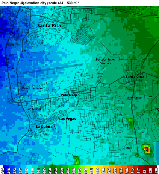
Below is the Elevation map of Palo Negro, which displays elevation range with different colors. Scale of the first map is from 414 to 530 m (1358 to 1739 ft) with average elevation of 436.7 meters (=1433 ft) [note 1]
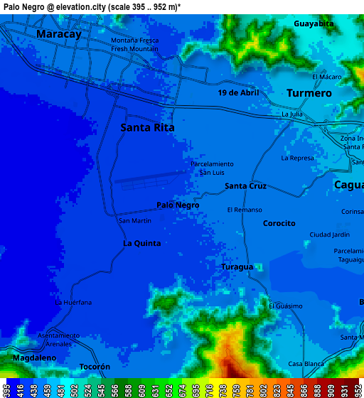
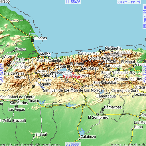
These maps also provides idea of topography and contour of this city, they are displayed at different zoom levels. More info about maps, scale and edge coordinates you can find below images.
| \ | Map #1 | Map #2 | Topo.Map |
| Scale [m] | 414..530 m | 395..952 m | × |
| Scale [ft] | 1358..1739 ft | 1296..3123 ft | × |
| Average | 436.7 m = 1433 ft | 458.2 m = 1503 ft | × |
| Width | 9.62 km = 6 mi | 19.24 km = 12 mi | 307.8 km = 191.3 mi |
| Height | 9.62 km = 6 mi | 19.24 km = 12 mi | 307.8 km = 191.3 mi |
| ↑Max Latitude | 10.217141° | 10.260387° | 11.5549° |
| Latitude at center | 10.17389° | 10.17389° | 10.17389° |
| ↓Min Latitude | 10.130633° | 10.08737° | 8.78688° |
| ← Min Longitude | -67.585885° | -67.629831° | -68.94819° |
| Longitude center | -67.54194° | -67.54194° | -67.54194° |
| →Max Longitude | -67.497995° | -67.454049° | -66.13569° |
Nearby cities:
Cities around Palo Negro sort by population:
• Maracay elevation 443 m
8.7 km,  321°
321°
• Turmero 475 m
9.6 km,  50°
50°
• El Limón 492 m
17.7 km,  326°
326°
• Cagua 465 m
9.1 km,  81°
81°
• Mariara 582 m
23.5 km,  305°
305°
• La Victoria 612 m
23.8 km, 75°
• Villa de Cura 523 m
16.1 km,  159°
159°
• Güigüe 590 m
27.7 km,  248°
248°
• San Mateo 497 m
13.7 km,  71°
71°
• San Joaquín 533 m
29.2 km,  289°
289°
• Santa Rita 581 m
4 km, 331°
• Santa Cruz 450 m
3.4 km, 78°
Multilingual:
 En español:
Palo Negro elevación 437 m.
 En France:
Palo Negro élévation 437 m.
 Auf Deutsch:
Palo Negro höhe über dem Meeresspiegel ist 437 m.

Sources and notes:
- [note 1] Map square and city borders are not equal. Map elevation data is calculated only from area inside that square.
- [src 1] Elevation data from geonames database provided with same terms of usage.
- [src 2] The elevation map of Palo Negro is generated using elevation data from NASA's 3 arcsec (90m) resolution SRTM data.
- [src 3] Base (background) map © OpenStreetMap contributors tiles are generated by Geofabrik and OpenTopoMap.
Copyright & License:
This Palo Negro Elevation Map is licensed under CC BY-SA. You may reuse any part from this page, if you give a proper credit by linking to this URL:
 More info on terms of use page.