Sheridan elevation
Sheridan (Wyoming, Sheridan County), United States elevation is 1147 meters and Sheridan elevation in feet is 3763 ft above sea level [src 1]. Sheridan is a seat of a second-order administrative division (feature code) with elevation that is 868 meters (2848 ft) bigger than average city elevation in United States.
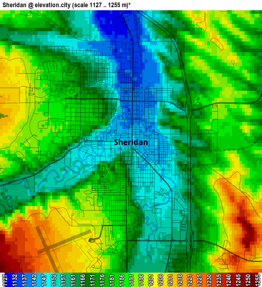
Below is the Elevation map of Sheridan, which displays elevation range with different colors. Scale of the first map is from 1127 to 1255 m (3698 to 4117 ft) with average elevation of 1177.8 meters (=3864 ft) [note 1]
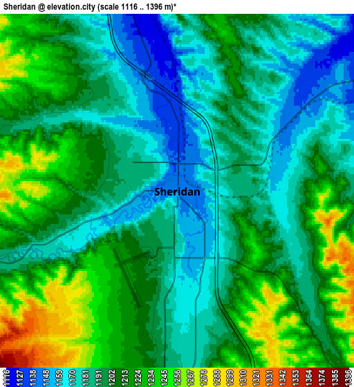
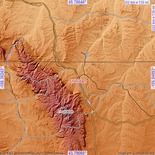
These maps also provides idea of topography and contour of this city, they are displayed at different zoom levels. More info about maps, scale and edge coordinates you can find below images.
| \ | Map #1 | Map #2 | Topo.Map |
| Scale [m] | 1127..1255 m | 1116..1396 m | × |
| Scale [ft] | 3698..4117 ft | 3661..4580 ft | × |
| Average | 1177.8 m = 3864 ft | 1201.3 m = 3941 ft | × |
| Width | 6.93 km = 4.3 mi | 13.87 km = 8.6 mi | 221.9 km = 137.9 mi |
| Height | 6.93 km = 4.3 mi | 13.87 km = 8.6 mi | 221.9 km = 137.9 mi |
| ↑Max Latitude | 44.828365° | 44.859524° | 45.78644° |
| Latitude at center | 44.79719° | 44.79719° | 44.79719° |
| ↓Min Latitude | 44.765998° | 44.734789° | 43.79068° |
| ← Min Longitude | -107.000125° | -107.044071° | -108.36243° |
| Longitude center | -106.95618° | -106.95618° | -106.95618° |
| →Max Longitude | -106.912235° | -106.868289° | -105.54993° |
Nearby cities:
Cities around Sheridan sort by population:
• Gillette elevation 1393 m
128.2 km,  116°
116°
• Worland 1240 m
117.6 km,  222°
222°
• Buffalo 1417 m
53.9 km,  157°
157°
• Hardin 886 m
116 km,  333°
333°
• Lovell 1168 m
113.1 km,  272°
272°
• Colstrip 986 m
123.6 km,  12°
12°
• Lame Deer 1017 m
94.6 km, 13°
• Greybull 1157 m
93.5 km,  248°
248°
• Antelope Valley-Crestview 1421 m
133.6 km, 118°
• Crow Agency 929 m
97.8 km,  336°
336°
• Sleepy Hollow 1381 m
136.4 km, 116°
• Basin 1181 m
97.5 km,  241°
241°
Multilingual:
 En español:
Sheridan elevación 1147 m.
 En France:
Sheridan élévation 1147 m.
 Auf Deutsch:
Sheridan höhe über dem Meeresspiegel ist 1147 m.

Sources and notes:
- [note 1] Map square and city borders are not equal. Map elevation data is calculated only from area inside that square.
- [src 1] Elevation data from geonames database provided with same terms of usage.
- [src 2] The elevation map of Sheridan is generated using elevation data from NASA's 3 arcsec (90m) resolution SRTM data.
- [src 3] Base (background) map © OpenStreetMap contributors tiles are generated by Geofabrik and OpenTopoMap.
Copyright & License:
This Sheridan Elevation Map is licensed under CC BY-SA. You may reuse any part from this page, if you give a proper credit by linking to this URL:
 More info on terms of use page.