Hardin elevation
Hardin (Montana, Big Horn County), United States elevation is 886 meters and Hardin elevation in feet is 2907 ft above sea level [src 1]. Hardin is a seat of a second-order administrative division (feature code) with elevation that is 607 meters (1991 ft) bigger than average city elevation in United States.
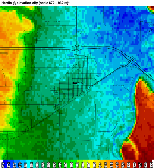
Below is the Elevation map of Hardin, which displays elevation range with different colors. Scale of the first map is from 872 to 932 m (2861 to 3058 ft) with average elevation of 890.7 meters (=2922 ft) [note 1]
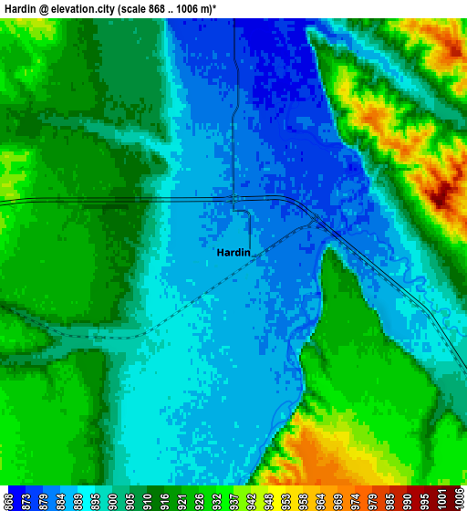
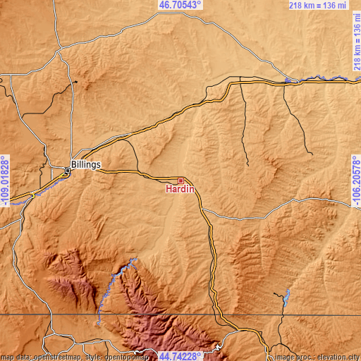
These maps also provides idea of topography and contour of this city, they are displayed at different zoom levels. More info about maps, scale and edge coordinates you can find below images.
| \ | Map #1 | Map #2 | Topo.Map |
| Scale [m] | 872..932 m | 868..1006 m | × |
| Scale [ft] | 2861..3058 ft | 2848..3301 ft | × |
| Average | 890.7 m = 2922 ft | 907.7 m = 2978 ft | × |
| Width | 6.82 km = 4.2 mi | 13.64 km = 8.5 mi | 218.3 km = 135.6 mi |
| Height | 6.82 km = 4.2 mi | 13.64 km = 8.5 mi | 218.3 km = 135.6 mi |
| ↑Max Latitude | 45.763146° | 45.793795° | 46.70543° |
| Latitude at center | 45.73248° | 45.73248° | 45.73248° |
| ↓Min Latitude | 45.701797° | 45.671098° | 44.74228° |
| ← Min Longitude | -107.655975° | -107.699921° | -109.01828° |
| Longitude center | -107.61203° | -107.61203° | -107.61203° |
| →Max Longitude | -107.568085° | -107.524139° | -106.20578° |
Nearby cities:
Cities around Hardin sort by population:
• Billings elevation 954 m
69.2 km,  274°
274°
• Sheridan 1147 m
116 km,  153°
153°
• Laurel 1006 m
90.3 km, 265°
• Lockwood 942 m
63 km,  278°
278°
• Lovell 1168 m
116.6 km,  211°
211°
• Colstrip 986 m
78.4 km,  77°
77°
• Lame Deer 1017 m
74.4 km,  99°
99°
• Columbus 1094 m
127.8 km, 265°
• Forsyth 769 m
93.4 km,  50°
50°
• Roundup 979 m
106.9 km,  317°
317°
• Crow Agency 929 m
18.7 km,  141°
141°
• Hysham 809 m
68.8 km,  25°
25°
Multilingual:
 En español:
Hardin elevación 886 m.
 En France:
Hardin élévation 886 m.


Sources and notes:
- [note 1] Map square and city borders are not equal. Map elevation data is calculated only from area inside that square.
- [src 1] Elevation data from geonames database provided with same terms of usage.
- [src 2] The elevation map of Hardin is generated using elevation data from NASA's 3 arcsec (90m) resolution SRTM data.
- [src 3] Base (background) map © OpenStreetMap contributors tiles are generated by Geofabrik and OpenTopoMap.
Copyright & License:
This Hardin Elevation Map is licensed under CC BY-SA. You may reuse any part from this page, if you give a proper credit by linking to this URL:
 More info on terms of use page.