Colstrip elevation
Colstrip (Montana, Rosebud County), United States elevation is 986 meters and Colstrip elevation in feet is 3235 ft above sea level [src 1]. Colstrip is a populated place (feature code) with elevation that is 707 meters (2320 ft) bigger than average city elevation in United States.
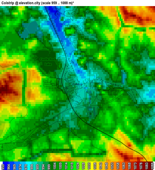
Below is the Elevation map of Colstrip, which displays elevation range with different colors. Scale of the first map is from 959 to 1088 m (3146 to 3570 ft) with average elevation of 1011.5 meters (=3319 ft) [note 1]
These maps also provides idea of topography and contour of this city, they are displayed at different zoom levels. More info about maps, scale and edge coordinates you can find below images.
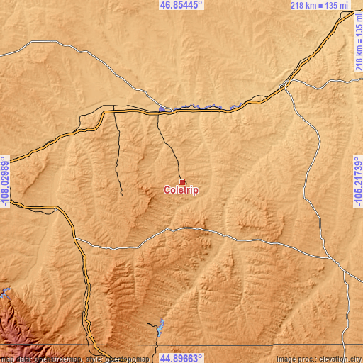
| \ | Map #1 | Topo.Map |
| Scale [m] | 959..1088 m | × |
| Scale [ft] | 3146..3570 ft | × |
| Average | 1011.5 m = 3319 ft | × |
| Width | 6.8 km = 4.2 mi | 217.7 km = 135.3 mi |
| Height | 6.8 km = 4.2 mi | 217.7 km = 135.3 mi |
| ↑Max Latitude | 45.914742° | 46.85445° |
| Latitude at center | 45.88416° | 45.88416° |
| ↓Min Latitude | 45.853561° | 44.89663° |
| ← Min Longitude | -106.667585° | -108.02989° |
| Longitude center | -106.62364° | -106.62364° |
| →Max Longitude | -106.579695° | -105.21739° |
Nearby cities:
Cities around Colstrip sort by population:
• Billings elevation 954 m
145.8 km,  265°
265°
• Sheridan 1147 m
123.6 km,  192°
192°
• Miles City 718 m
83.9 km,  45°
45°
• Lockwood 942 m
138.9 km, 267°
• Hardin 886 m
78.4 km,  257°
257°
• Lame Deer 1017 m
29.2 km, 186°
• Forsyth 769 m
42.7 km,  354°
354°
• Crow Agency 929 m
72.2 km,  244°
244°
• Terry 686 m
142.6 km,  44°
44°
• Broadus 928 m
106.2 km,  117°
117°
• Ekalaka 1042 m
160.3 km,  89°
89°
• Hysham 809 m
65.4 km,  313°
313°
Multilingual:
 En español:
Colstrip elevación 986 m.
 En France:
Colstrip élévation 986 m.
 Auf Deutsch:
Colstrip höhe über dem Meeresspiegel ist 986 m.

Sources and notes:
- [note 1] Map square and city borders are not equal. Map elevation data is calculated only from area inside that square.
- [src 1] Elevation data from geonames database provided with same terms of usage.
- [src 2] The elevation map of Colstrip is generated using elevation data from NASA's 3 arcsec (90m) resolution SRTM data.
- [src 3] Base (background) map © OpenStreetMap contributors tiles are generated by Geofabrik and OpenTopoMap.
Copyright & License:
This Colstrip Elevation Map is licensed under CC BY-SA. You may reuse any part from this page, if you give a proper credit by linking to this URL:
 More info on terms of use page.