Broadus elevation
Broadus (Montana, Powder River County), United States elevation is 928 meters and Broadus elevation in feet is 3045 ft above sea level [src 1]. Broadus is a seat of a second-order administrative division (feature code) with elevation that is 649 meters (2129 ft) bigger than average city elevation in United States.
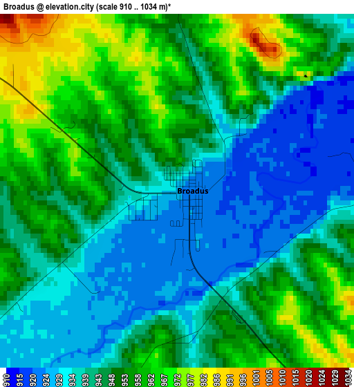
Below is the Elevation map of Broadus, which displays elevation range with different colors. Scale of the first map is from 910 to 1034 m (2986 to 3392 ft) with average elevation of 946.5 meters (=3105 ft) [note 1]
These maps also provides idea of topography and contour of this city, they are displayed at different zoom levels. More info about maps, scale and edge coordinates you can find below images.
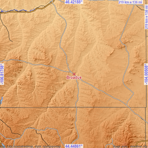
| \ | Map #1 | Topo.Map |
| Scale [m] | 910..1034 m | × |
| Scale [ft] | 2986..3392 ft | × |
| Average | 946.5 m = 3105 ft | × |
| Width | 6.86 km = 4.3 mi | 219.4 km = 136.3 mi |
| Height | 6.86 km = 4.3 mi | 219.4 km = 136.3 mi |
| ↑Max Latitude | 45.474694° | 46.42188° |
| Latitude at center | 45.44387° | 45.44387° |
| ↓Min Latitude | 45.413029° | 44.44861° |
| ← Min Longitude | -105.455275° | -106.81758° |
| Longitude center | -105.41133° | -105.41133° |
| →Max Longitude | -105.367385° | -104.00508° |
Nearby cities:
Cities around Broadus sort by population:
• Gillette elevation 1393 m
128.4 km,  183°
183°
• Sheridan 1147 m
140.9 km,  239°
239°
• Miles City 718 m
112.3 km,  342°
342°
• Colstrip 986 m
106.2 km,  297°
297°
• Lame Deer 1017 m
99.8 km,  281°
281°
• Baker 888 m
134.7 km,  40°
40°
• Forsyth 769 m
134.1 km,  312°
312°
• Antelope Valley-Crestview 1421 m
135.6 km, 182°
• Sleepy Hollow 1381 m
133.7 km, 180°
• Sundance 1450 m
141.3 km,  144°
144°
• Moorcroft 1290 m
136.2 km,  164°
164°
• Ekalaka 1042 m
83.1 km,  53°
53°
Multilingual:
 En español:
Broadus elevación 928 m.
 En France:
Broadus élévation 928 m.


Sources and notes:
- [note 1] Map square and city borders are not equal. Map elevation data is calculated only from area inside that square.
- [src 1] Elevation data from geonames database provided with same terms of usage.
- [src 2] The elevation map of Broadus is generated using elevation data from NASA's 3 arcsec (90m) resolution SRTM data.
- [src 3] Base (background) map © OpenStreetMap contributors tiles are generated by Geofabrik and OpenTopoMap.
Copyright & License:
This Broadus Elevation Map is licensed under CC BY-SA. You may reuse any part from this page, if you give a proper credit by linking to this URL:
 More info on terms of use page.