Baker elevation
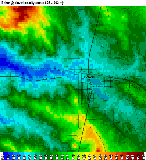
Baker (Montana, Fallon County), United States elevation is 888 meters and Baker elevation in feet is 2913 ft above sea level [src 1]. Baker is a seat of a second-order administrative division (feature code) with elevation that is 609 meters (1998 ft) bigger than average city elevation in United States.
Below is the Elevation map of Baker, which displays elevation range with different colors. Scale of the first map is from 875 to 962 m (2871 to 3156 ft) with average elevation of 903.8 meters (=2965 ft) [note 1]
These maps also provides idea of topography and contour of this city, they are displayed at different zoom levels. More info about maps, scale and edge coordinates you can find below images.
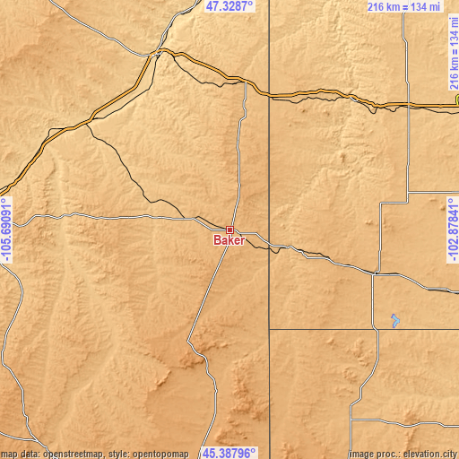
| \ | Map #1 | Topo.Map |
| Scale [m] | 875..962 m | × |
| Scale [ft] | 2871..3156 ft | × |
| Average | 903.8 m = 2965 ft | × |
| Width | 6.74 km = 4.2 mi | 215.8 km = 134.1 mi |
| Height | 6.74 km = 4.2 mi | 215.8 km = 134.1 mi |
| ↑Max Latitude | 46.397265° | 47.3287° |
| Latitude at center | 46.36695° | 46.36695° |
| ↓Min Latitude | 46.336618° | 45.38796° |
| ← Min Longitude | -104.328605° | -105.69091° |
| Longitude center | -104.28466° | -104.28466° |
| →Max Longitude | -104.240715° | -102.87841° |
Nearby cities:
Cities around Baker sort by population:
• Miles City elevation 718 m
119.4 km,  272°
272°
• Glendive 633 m
88.3 km,  338°
338°
• West Glendive 644 m
90 km, 336°
• Bowman 903 m
71.4 km,  106°
106°
• Beach 843 m
64.9 km,  19°
19°
• Belfield 787 m
100.9 km,  55°
55°
• Wibaux 804 m
69.1 km,  6°
6°
• Terry 686 m
91.7 km,  301°
301°
• Buffalo 878 m
104.1 km,  146°
146°
• Ekalaka 1042 m
57 km,  201°
201°
• Medora 691 m
84.1 km,  43°
43°
• Amidon 885 m
74.9 km,  80°
80°
Multilingual:
 En español:
Baker elevación 888 m.
 En France:
Baker élévation 888 m.


Sources and notes:
- [note 1] Map square and city borders are not equal. Map elevation data is calculated only from area inside that square.
- [src 1] Elevation data from geonames database provided with same terms of usage.
- [src 2] The elevation map of Baker is generated using elevation data from NASA's 3 arcsec (90m) resolution SRTM data.
- [src 3] Base (background) map © OpenStreetMap contributors tiles are generated by Geofabrik and OpenTopoMap.
Copyright & License:
This Baker Elevation Map is licensed under CC BY-SA. You may reuse any part from this page, if you give a proper credit by linking to this URL:
 More info on terms of use page.