Gillette elevation
Gillette (Wyoming, Campbell County), United States elevation is 1393 meters and Gillette elevation in feet is 4570 ft above sea level [src 1]. Gillette is a seat of a second-order administrative division (feature code) with elevation that is 1114 meters (3655 ft) bigger than average city elevation in United States.
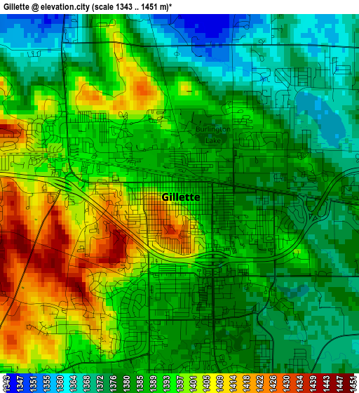
Below is the Elevation map of Gillette, which displays elevation range with different colors. Scale of the first map is from 1343 to 1451 m (4406 to 4760 ft) with average elevation of 1388.1 meters (=4554 ft) [note 1]
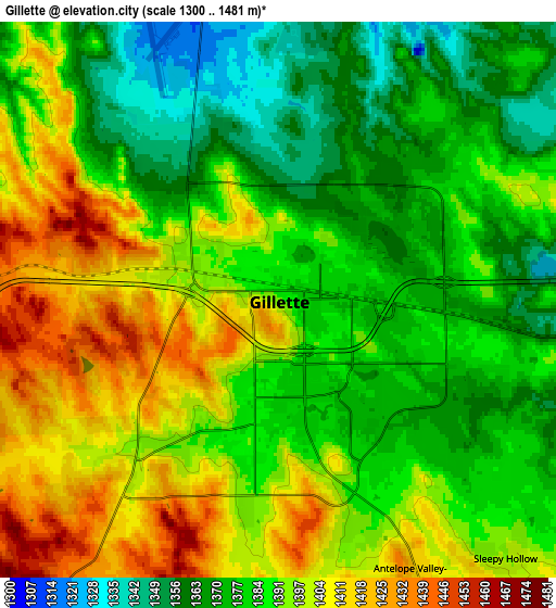
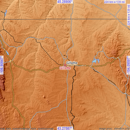
These maps also provides idea of topography and contour of this city, they are displayed at different zoom levels. More info about maps, scale and edge coordinates you can find below images.
| \ | Map #1 | Map #2 | Topo.Map |
| Scale [m] | 1343..1451 m | 1300..1481 m | × |
| Scale [ft] | 4406..4760 ft | 4265..4859 ft | × |
| Average | 1388.1 m = 4554 ft | 1388.7 m = 4556 ft | × |
| Width | 7 km = 4.3 mi | 13.99 km = 8.7 mi | 223.8 km = 139.1 mi |
| Height | 7 km = 4.3 mi | 13.99 km = 8.7 mi | 223.8 km = 139.1 mi |
| ↑Max Latitude | 44.322538° | 44.353969° | 45.28906° |
| Latitude at center | 44.29109° | 44.29109° | 44.29109° |
| ↓Min Latitude | 44.259625° | 44.228144° | 43.27587° |
| ← Min Longitude | -105.546165° | -105.590111° | -106.90847° |
| Longitude center | -105.50222° | -105.50222° | -105.50222° |
| →Max Longitude | -105.458275° | -105.414329° | -104.09597° |
Nearby cities:
Cities around Gillette sort by population:
• Sheridan elevation 1147 m
128.2 km,  296°
296°
• Spearfish 1110 m
132.4 km,  80°
80°
• Buffalo 1417 m
95.4 km,  273°
273°
• Newcastle 1323 m
114.4 km,  115°
115°
• North Spearfish 1106 m
130.1 km, 79°
• Wright 1519 m
60 km,  179°
179°
• Antelope Valley-Crestview 1421 m
7.7 km,  163°
163°
• Sleepy Hollow 1381 m
8.5 km,  131°
131°
• Sundance 1450 m
90.5 km, 81°
• Upton 1289 m
72.9 km,  106°
106°
• Moorcroft 1290 m
44 km,  94°
94°
• Broadus 928 m
128.4 km,  3°
3°
Multilingual:
 En español:
Gillette elevación 1393 m.
 En France:
Gillette élévation 1393 m.
 Auf Deutsch:
Gillette höhe über dem Meeresspiegel ist 1393 m.

Sources and notes:
- [note 1] Map square and city borders are not equal. Map elevation data is calculated only from area inside that square.
- [src 1] Elevation data from geonames database provided with same terms of usage.
- [src 2] The elevation map of Gillette is generated using elevation data from NASA's 3 arcsec (90m) resolution SRTM data.
- [src 3] Base (background) map © OpenStreetMap contributors tiles are generated by Geofabrik and OpenTopoMap.
Copyright & License:
This Gillette Elevation Map is licensed under CC BY-SA. You may reuse any part from this page, if you give a proper credit by linking to this URL:
 More info on terms of use page.