Upton elevation
Upton (Wyoming, Weston County), United States elevation is 1289 meters and Upton elevation in feet is 4229 ft above sea level [src 1]. Upton is a populated place (feature code) with elevation that is 1010 meters (3314 ft) bigger than average city elevation in United States.
Below is the Elevation map of Upton, which displays elevation range with different colors. Scale of the first map is from 1267 to 1345 m (4157 to 4413 ft) with average elevation of 1299.9 meters (=4265 ft) [note 1]
These maps also provides idea of topography and contour of this city, they are displayed at different zoom levels. More info about maps, scale and edge coordinates you can find below images.
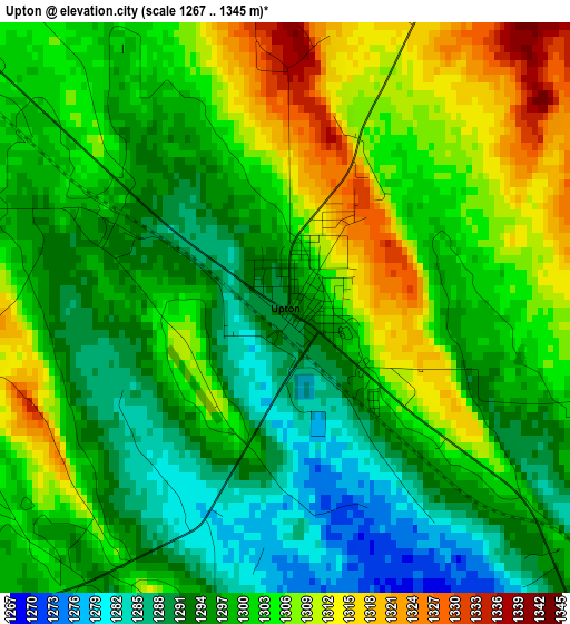
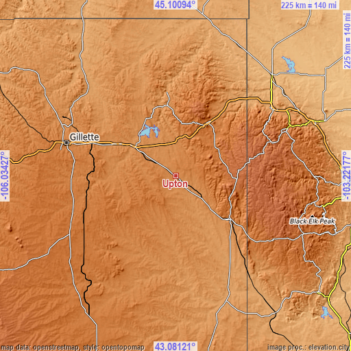
| \ | Map #1 | Topo.Map |
| Scale [m] | 1267..1345 m | × |
| Scale [ft] | 4157..4413 ft | × |
| Average | 1299.9 m = 4265 ft | × |
| Width | 7.02 km = 4.4 mi | 224.6 km = 139.6 mi |
| Height | 7.02 km = 4.4 mi | 224.6 km = 139.6 mi |
| ↑Max Latitude | 44.13125° | 45.10094° |
| Latitude at center | 44.0997° | 44.0997° |
| ↓Min Latitude | 44.068133° | 43.08121° |
| ← Min Longitude | -104.671965° | -106.03427° |
| Longitude center | -104.62802° | -104.62802° |
| →Max Longitude | -104.584075° | -103.22177° |
Nearby cities:
Cities around Upton sort by population:
• Gillette elevation 1393 m
72.9 km,  286°
286°
• Spearfish 1110 m
75.1 km,  54°
54°
• Belle Fourche 921 m
88.6 km,  44°
44°
• Newcastle 1323 m
43.5 km,  128°
128°
• Lead 1572 m
74.3 km,  67°
67°
• North Spearfish 1106 m
74 km, 52°
• Wright 1519 m
79.3 km,  240°
240°
• Antelope Valley-Crestview 1421 m
68.9 km,  281°
281°
• Sleepy Hollow 1381 m
65.3 km, 283°
• Sundance 1450 m
39.6 km,  30°
30°
• Deadwood 1389 m
77.9 km, 66°
• Moorcroft 1290 m
31.5 km,  305°
305°
Multilingual:
 En español:
Upton elevación 1289 m.
 En France:
Upton élévation 1289 m.


Sources and notes:
- [note 1] Map square and city borders are not equal. Map elevation data is calculated only from area inside that square.
- [src 1] Elevation data from geonames database provided with same terms of usage.
- [src 2] The elevation map of Upton is generated using elevation data from NASA's 3 arcsec (90m) resolution SRTM data.
- [src 3] Base (background) map © OpenStreetMap contributors tiles are generated by Geofabrik and OpenTopoMap.
Copyright & License:
This Upton Elevation Map is licensed under CC BY-SA. You may reuse any part from this page, if you give a proper credit by linking to this URL:
 More info on terms of use page.