Worland elevation
Worland (Wyoming, Washakie County), United States elevation is 1240 meters and Worland elevation in feet is 4068 ft above sea level [src 1]. Worland is a seat of a second-order administrative division (feature code) with elevation that is 961 meters (3153 ft) bigger than average city elevation in United States.
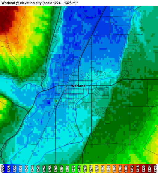
Below is the Elevation map of Worland, which displays elevation range with different colors. Scale of the first map is from 1224 to 1328 m (4016 to 4357 ft) with average elevation of 1251.6 meters (=4106 ft) [note 1]
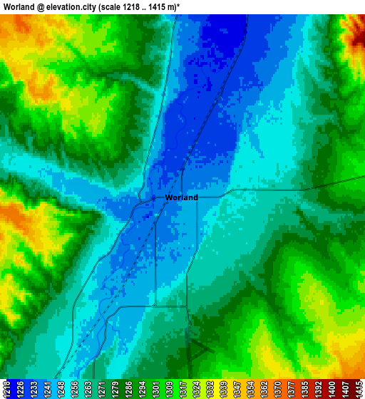
These maps also provides idea of topography and contour of this city, they are displayed at different zoom levels. More info about maps, scale and edge coordinates you can find below images.
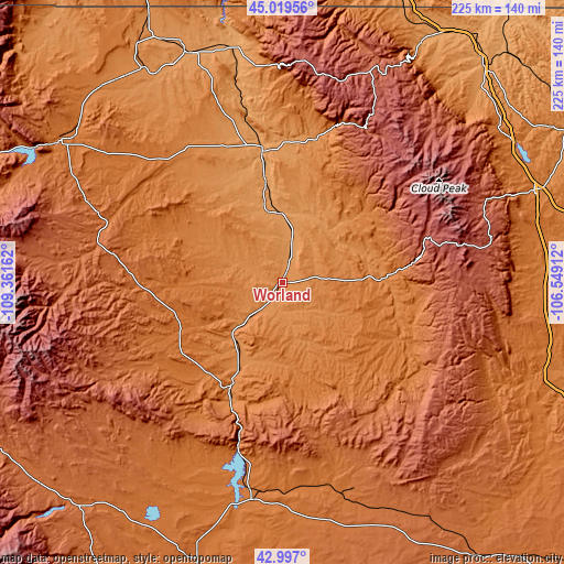
| \ | Map #1 | Map #2 | Topo.Map |
| Scale [m] | 1224..1328 m | 1218..1415 m | × |
| Scale [ft] | 4016..4357 ft | 3996..4642 ft | × |
| Average | 1251.6 m = 4106 ft | 1277 m = 4190 ft | × |
| Width | 7.03 km = 4.4 mi | 14.06 km = 8.7 mi | 224.9 km = 139.7 mi |
| Height | 7.03 km = 4.4 mi | 14.06 km = 8.7 mi | 224.9 km = 139.7 mi |
| ↑Max Latitude | 44.048494° | 44.080072° | 45.01956° |
| Latitude at center | 44.0169° | 44.0169° | 44.0169° |
| ↓Min Latitude | 43.985289° | 43.953661° | 42.997° |
| ← Min Longitude | -107.999315° | -108.043261° | -109.36162° |
| Longitude center | -107.95537° | -107.95537° | -107.95537° |
| →Max Longitude | -107.911425° | -107.867479° | -106.54912° |
Nearby cities:
Cities around Worland sort by population:
• Sheridan elevation 1147 m
117.6 km,  42°
42°
• Riverton 1512 m
115.5 km,  197°
197°
• Cody 1525 m
104.4 km,  302°
302°
• Powell 1340 m
103.8 km,  322°
322°
• Buffalo 1417 m
106.7 km,  69°
69°
• Thermopolis 1323 m
46.1 km,  206°
206°
• Lovell 1168 m
97.5 km,  339°
339°
• Greybull 1157 m
53.1 km,  351°
351°
• Fort Washakie 1696 m
135 km, 213°
• Arapahoe 1533 m
124.9 km, 200°
• Ethete 1634 m
128.5 km, 210°
• Basin 1181 m
40.9 km, 350°
Multilingual:
 En español:
Worland elevación 1240 m.
 En France:
Worland élévation 1240 m.
 Auf Deutsch:
Worland höhe über dem Meeresspiegel ist 1240 m.

Sources and notes:
- [note 1] Map square and city borders are not equal. Map elevation data is calculated only from area inside that square.
- [src 1] Elevation data from geonames database provided with same terms of usage.
- [src 2] The elevation map of Worland is generated using elevation data from NASA's 3 arcsec (90m) resolution SRTM data.
- [src 3] Base (background) map © OpenStreetMap contributors tiles are generated by Geofabrik and OpenTopoMap.
Copyright & License:
This Worland Elevation Map is licensed under CC BY-SA. You may reuse any part from this page, if you give a proper credit by linking to this URL:
 More info on terms of use page.