Riverton elevation
Riverton (Wyoming, Fremont County), United States elevation is 1512 meters and Riverton elevation in feet is 4961 ft above sea level [src 1]. Riverton is a populated place (feature code) with elevation that is 1233 meters (4045 ft) bigger than average city elevation in United States.
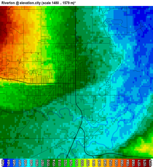
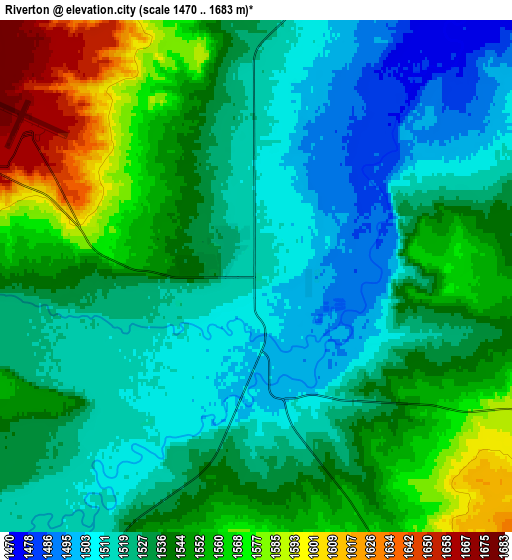
Below is the Elevation map of Riverton, which displays elevation range with different colors. Scale of the first map is from 1480 to 1579 m (4856 to 5180 ft) with average elevation of 1511.6 meters (=4959 ft) [note 1]
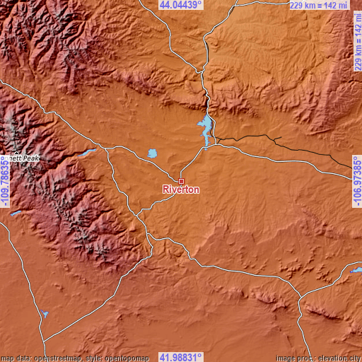
These maps also provides idea of topography and contour of this city, they are displayed at different zoom levels. More info about maps, scale and edge coordinates you can find below images.
| \ | Map #1 | Map #2 | Topo.Map |
| Scale [m] | 1480..1579 m | 1470..1683 m | × |
| Scale [ft] | 4856..5180 ft | 4823..5522 ft | × |
| Average | 1511.6 m = 4959 ft | 1536.6 m = 5041 ft | × |
| Width | 7.14 km = 4.4 mi | 14.29 km = 8.9 mi | 228.6 km = 142 mi |
| Height | 7.14 km = 4.4 mi | 14.29 km = 8.9 mi | 228.6 km = 142 mi |
| ↑Max Latitude | 43.057078° | 43.089179° | 44.04439° |
| Latitude at center | 43.02496° | 43.02496° | 43.02496° |
| ↓Min Latitude | 42.992825° | 42.960673° | 41.98831° |
| ← Min Longitude | -108.424045° | -108.467991° | -109.78635° |
| Longitude center | -108.3801° | -108.3801° | -108.3801° |
| →Max Longitude | -108.336155° | -108.292209° | -106.97385° |
Nearby cities:
Cities around Riverton sort by population:
• Rawlins elevation 2075 m
166.1 km,  145°
145°
• Lander 1637 m
35.6 km,  233°
233°
• Worland 1240 m
115.5 km,  17°
17°
• Mills 1564 m
165.2 km,  97°
97°
• Thermopolis 1323 m
70.4 km,  11°
11°
• Pinedale 2190 m
121.8 km,  261°
261°
• Greybull 1157 m
164.9 km, 9°
• Fort Washakie 1696 m
40.9 km,  267°
267°
• Arapahoe 1533 m
11.3 km, 231°
• Ethete 1634 m
31.9 km, 270°
• Basin 1181 m
153.1 km, 10°
• Marbleton 2095 m
150.5 km,  249°
249°
Multilingual:
 En español:
Riverton elevación 1512 m.
 En France:
Riverton élévation 1512 m.
 Auf Deutsch:
Riverton höhe über dem Meeresspiegel ist 1512 m.

Sources and notes:
- [note 1] Map square and city borders are not equal. Map elevation data is calculated only from area inside that square.
- [src 1] Elevation data from geonames database provided with same terms of usage.
- [src 2] The elevation map of Riverton is generated using elevation data from NASA's 3 arcsec (90m) resolution SRTM data.
- [src 3] Base (background) map © OpenStreetMap contributors tiles are generated by Geofabrik and OpenTopoMap.
Copyright & License:
This Riverton Elevation Map is licensed under CC BY-SA. You may reuse any part from this page, if you give a proper credit by linking to this URL:
 More info on terms of use page.