Rawlins elevation
Rawlins (Wyoming, Carbon County), United States elevation is 2075 meters and Rawlins elevation in feet is 6808 ft above sea level [src 1]. Rawlins is a seat of a second-order administrative division (feature code) with elevation that is 1796 meters (5892 ft) bigger than average city elevation in United States.
Below is the Elevation map of Rawlins, which displays elevation range with different colors. Scale of the first map is from 2025 to 2371 m (6644 to 7779 ft) with average elevation of 2101.4 meters (=6894 ft) [note 1]
These maps also provides idea of topography and contour of this city, they are displayed at different zoom levels. More info about maps, scale and edge coordinates you can find below images.
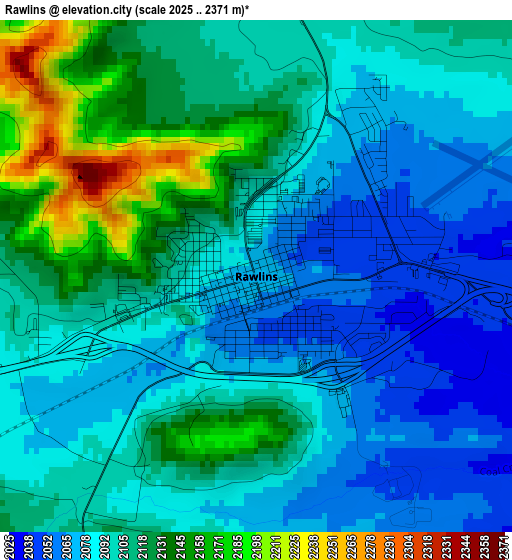
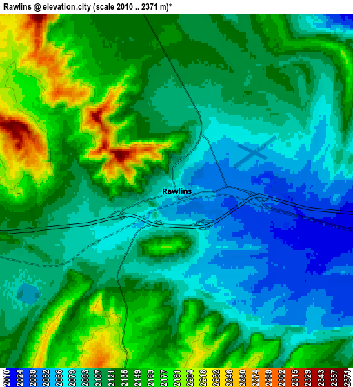
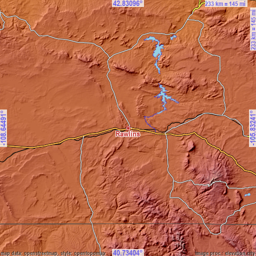
| \ | Map #1 | Map #2 | Topo.Map |
| Scale [m] | 2025..2371 m | 2010..2371 m | × |
| Scale [ft] | 6644..7779 ft | 6594..7779 ft | × |
| Average | 2101.4 m = 6894 ft | 2120.4 m = 6957 ft | × |
| Width | 7.29 km = 4.5 mi | 14.57 km = 9.1 mi | 233.2 km = 144.9 mi |
| Height | 7.29 km = 4.5 mi | 14.57 km = 9.1 mi | 233.1 km = 144.8 mi |
| ↑Max Latitude | 41.823826° | 41.856566° | 42.83096° |
| Latitude at center | 41.79107° | 41.79107° | 41.79107° |
| ↓Min Latitude | 41.758297° | 41.725507° | 40.73404° |
| ← Min Longitude | -107.282605° | -107.326551° | -108.64491° |
| Longitude center | -107.23866° | -107.23866° | -107.23866° |
| →Max Longitude | -107.194715° | -107.150769° | -105.83241° |
Nearby cities:
Cities around Rawlins sort by population:
• Casper elevation 1560 m
141.7 km,  32°
32°
• Laramie 2190 m
147.1 km,  111°
111°
• Rock Springs 1954 m
164.7 km,  262°
262°
• Steamboat Springs 2058 m
149.2 km,  166°
166°
• Craig 1891 m
144.2 km,  190°
190°
• Mills 1564 m
137 km, 31°
• Evansville 1563 m
143.1 km, 33°
• Bar Nunn 1608 m
144.9 km, 30°
• Glenrock 1529 m
163.6 km,  43°
43°
• Hayden 1937 m
144.1 km,  180°
180°
• Saratoga 2073 m
51.8 km,  136°
136°
• Walden 2472 m
142.3 km,  145°
145°
Multilingual:
 En español:
Rawlins elevación 2075 m.
 En France:
Rawlins élévation 2075 m.
 Auf Deutsch:
Rawlins höhe über dem Meeresspiegel ist 2075 m.

Sources and notes:
- [note 1] Map square and city borders are not equal. Map elevation data is calculated only from area inside that square.
- [src 1] Elevation data from geonames database provided with same terms of usage.
- [src 2] The elevation map of Rawlins is generated using elevation data from NASA's 3 arcsec (90m) resolution SRTM data.
- [src 3] Base (background) map © OpenStreetMap contributors tiles are generated by Geofabrik and OpenTopoMap.
Copyright & License:
This Rawlins Elevation Map is licensed under CC BY-SA. You may reuse any part from this page, if you give a proper credit by linking to this URL:
 More info on terms of use page.