Evansville elevation
Evansville (Wyoming, Natrona County), United States elevation is 1563 meters and Evansville elevation in feet is 5128 ft above sea level [src 1]. Evansville is a populated place (feature code) with elevation that is 1284 meters (4213 ft) bigger than average city elevation in United States.
Below is the Elevation map of Evansville, which displays elevation range with different colors. Scale of the first map is from 1542 to 1650 m (5059 to 5413 ft) with average elevation of 1582.1 meters (=5191 ft) [note 1]
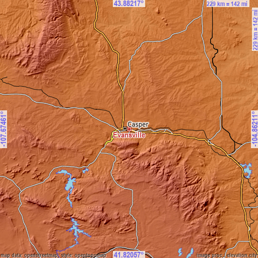
These maps also provides idea of topography and contour of this city, they are displayed at different zoom levels. More info about maps, scale and edge coordinates you can find below images.
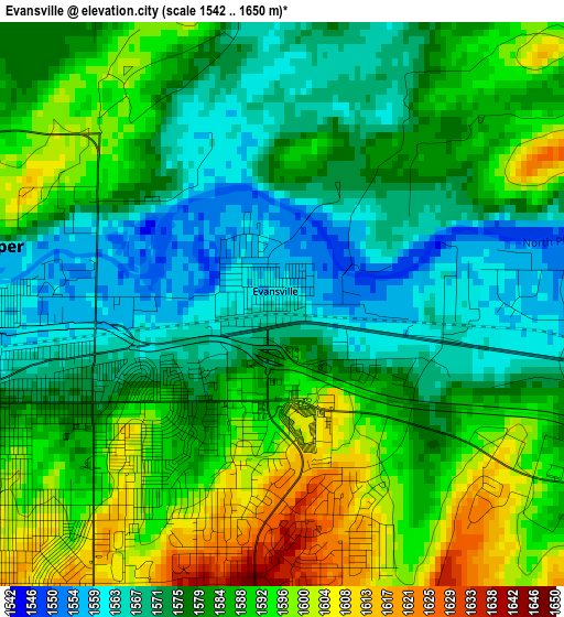
| \ | Map #1 | Topo.Map |
| Scale [m] | 1542..1650 m | × |
| Scale [ft] | 5059..5413 ft | × |
| Average | 1582.1 m = 5191 ft | × |
| Width | 7.16 km = 4.4 mi | 229.2 km = 142.4 mi |
| Height | 7.16 km = 4.4 mi | 229.2 km = 142.4 mi |
| ↑Max Latitude | 42.892174° | 43.88217° |
| Latitude at center | 42.85997° | 42.85997° |
| ↓Min Latitude | 42.827749° | 41.82057° |
| ← Min Longitude | -106.312305° | -107.67461° |
| Longitude center | -106.26836° | -106.26836° |
| →Max Longitude | -106.224415° | -104.86211° |
Nearby cities:
Cities around Evansville sort by population:
• Casper elevation 1560 m
3.7 km,  281°
281°
• Rawlins 2075 m
143.1 km,  213°
213°
• Douglas 1474 m
73.1 km,  98°
98°
• Mills 1564 m
8.2 km,  254°
254°
• Wheatland 1449 m
140.3 km,  129°
129°
• Bar Nunn 1608 m
8.5 km,  314°
314°
• Glenrock 1529 m
32.3 km,  89°
89°
• Wright 1519 m
117.3 km,  32°
32°
• Saratoga 2073 m
162.4 km,  195°
195°
• Antelope Valley-Crestview 1421 m
164.7 km,  22°
22°
• Lusk 1533 m
148.5 km, 94°
• Guernsey 1326 m
141.2 km,  117°
117°
Multilingual:
 En español:
Evansville elevación 1563 m.
 En France:
Evansville élévation 1563 m.
 Auf Deutsch:
Evansville höhe über dem Meeresspiegel ist 1563 m.

Sources and notes:
- [note 1] Map square and city borders are not equal. Map elevation data is calculated only from area inside that square.
- [src 1] Elevation data from geonames database provided with same terms of usage.
- [src 2] The elevation map of Evansville is generated using elevation data from NASA's 3 arcsec (90m) resolution SRTM data.
- [src 3] Base (background) map © OpenStreetMap contributors tiles are generated by Geofabrik and OpenTopoMap.
Copyright & License:
This Evansville Elevation Map is licensed under CC BY-SA. You may reuse any part from this page, if you give a proper credit by linking to this URL:
 More info on terms of use page.