Walden elevation
Walden (Colorado, Jackson County), United States elevation is 2472 meters and Walden elevation in feet is 8110 ft above sea level [src 1]. Walden is a seat of a second-order administrative division (feature code) with elevation that is 2193 meters (7195 ft) bigger than average city elevation in United States.
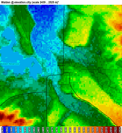
Below is the Elevation map of Walden, which displays elevation range with different colors. Scale of the first map is from 2439 to 2525 m (8002 to 8284 ft) with average elevation of 2470 meters (=8104 ft) [note 1]
These maps also provides idea of topography and contour of this city, they are displayed at different zoom levels. More info about maps, scale and edge coordinates you can find below images.
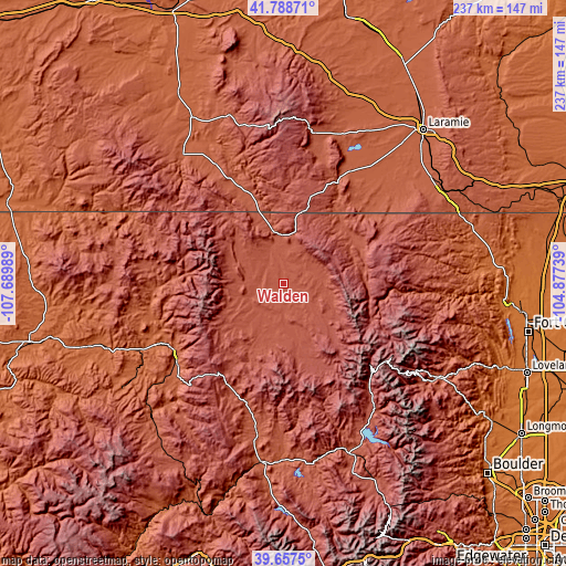
| \ | Map #1 | Topo.Map |
| Scale [m] | 2439..2525 m | × |
| Scale [ft] | 8002..8284 ft | × |
| Average | 2470 m = 8104 ft | × |
| Width | 7.41 km = 4.6 mi | 237 km = 147.3 mi |
| Height | 7.41 km = 4.6 mi | 237 km = 147.3 mi |
| ↑Max Latitude | 40.764932° | 41.78871° |
| Latitude at center | 40.73164° | 40.73164° |
| ↓Min Latitude | 40.698331° | 39.6575° |
| ← Min Longitude | -106.327585° | -107.68989° |
| Longitude center | -106.28364° | -106.28364° |
| →Max Longitude | -106.239695° | -104.87739° |
Nearby cities:
Cities around Walden sort by population:
• Fort Collins elevation 1531 m
102.5 km,  99°
99°
• Laramie 2190 m
86.8 km,  42°
42°
• Steamboat Springs 2058 m
53.8 km,  239°
239°
• Estes Park 2302 m
75.5 km,  121°
121°
• Laporte 1546 m
97.2 km, 96°
• Lyons 1643 m
102.5 km, 123°
• Granby 2434 m
77.5 km,  157°
157°
• Hayden 1937 m
86.3 km,  252°
252°
• Saratoga 2073 m
91.6 km,  331°
331°
• Kremmling 2250 m
75.3 km,  186°
186°
• Fraser 2619 m
96 km, 155°
• Hot Sulphur Springs 2361 m
74.8 km,  168°
168°
Multilingual:
 En español:
Walden elevación 2472 m.
 En France:
Walden élévation 2472 m.


Sources and notes:
- [note 1] Map square and city borders are not equal. Map elevation data is calculated only from area inside that square.
- [src 1] Elevation data from geonames database provided with same terms of usage.
- [src 2] The elevation map of Walden is generated using elevation data from NASA's 3 arcsec (90m) resolution SRTM data.
- [src 3] Base (background) map © OpenStreetMap contributors tiles are generated by Geofabrik and OpenTopoMap.
Copyright & License:
This Walden Elevation Map is licensed under CC BY-SA. You may reuse any part from this page, if you give a proper credit by linking to this URL:
 More info on terms of use page.