Fraser elevation
Fraser (Colorado, Grand County), United States elevation is 2619 meters and Fraser elevation in feet is 8593 ft above sea level [src 1]. Fraser is a populated place (feature code) with elevation that is 2340 meters (7677 ft) bigger than average city elevation in United States.
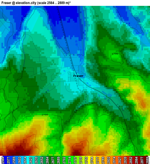
Below is the Elevation map of Fraser, which displays elevation range with different colors. Scale of the first map is from 2564 to 2889 m (8412 to 9478 ft) with average elevation of 2672.4 meters (=8768 ft) [note 1]
These maps also provides idea of topography and contour of this city, they are displayed at different zoom levels. More info about maps, scale and edge coordinates you can find below images.
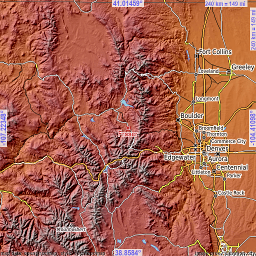
| \ | Map #1 | Topo.Map |
| Scale [m] | 2564..2889 m | × |
| Scale [ft] | 8412..9478 ft | × |
| Average | 2672.4 m = 8768 ft | × |
| Width | 7.49 km = 4.7 mi | 239.7 km = 148.9 mi |
| Height | 7.49 km = 4.7 mi | 239.7 km = 148.9 mi |
| ↑Max Latitude | 39.978673° | 41.01459° |
| Latitude at center | 39.94499° | 39.94499° |
| ↓Min Latitude | 39.911291° | 38.8584° |
| ← Min Longitude | -105.861175° | -107.22348° |
| Longitude center | -105.81723° | -105.81723° |
| →Max Longitude | -105.773285° | -104.41098° |
Nearby cities:
Cities around Fraser sort by population:
• Boulder elevation 1630 m
47.2 km,  80°
80°
• Silverthorne 2669 m
41.1 km,  212°
212°
• Frisco 2770 m
47.7 km, 210°
• Coal Creek 2631 m
37.7 km,  96°
96°
• Granby 2434 m
18.8 km,  326°
326°
• Idaho Springs 2300 m
34.3 km,  130°
130°
• Nederland 2517 m
26.2 km,  86°
86°
• Keystone 2798 m
41.1 km,  200°
200°
• Upper Bear Creek 2360 m
49.4 km,  136°
136°
• Georgetown 2603 m
28.5 km,  158°
158°
• Central City 2596 m
30.4 km,  121°
121°
• Hot Sulphur Springs 2361 m
28.2 km,  300°
300°
Multilingual:
 En español:
Fraser elevación 2619 m.
 En France:
Fraser élévation 2619 m.


Sources and notes:
- [note 1] Map square and city borders are not equal. Map elevation data is calculated only from area inside that square.
- [src 1] Elevation data from geonames database provided with same terms of usage.
- [src 2] The elevation map of Fraser is generated using elevation data from NASA's 3 arcsec (90m) resolution SRTM data.
- [src 3] Base (background) map © OpenStreetMap contributors tiles are generated by Geofabrik and OpenTopoMap.
Copyright & License:
This Fraser Elevation Map is licensed under CC BY-SA. You may reuse any part from this page, if you give a proper credit by linking to this URL:
 More info on terms of use page.