Boulder elevation
Boulder (Colorado, Boulder County), United States elevation is 1630 meters and Boulder elevation in feet is 5348 ft above sea level [src 1]. Boulder is a seat of a second-order administrative division (feature code) with elevation that is 1351 meters (4432 ft) bigger than average city elevation in United States.
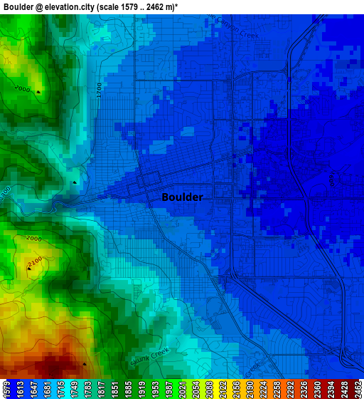
Below is the Elevation map of Boulder, which displays elevation range with different colors. Scale of the first map is from 1579 to 2462 m (5180 to 8077 ft) with average elevation of 1729 meters (=5673 ft) [note 1]
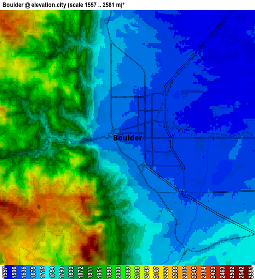
These maps also provides idea of topography and contour of this city, they are displayed at different zoom levels. More info about maps, scale and edge coordinates you can find below images.
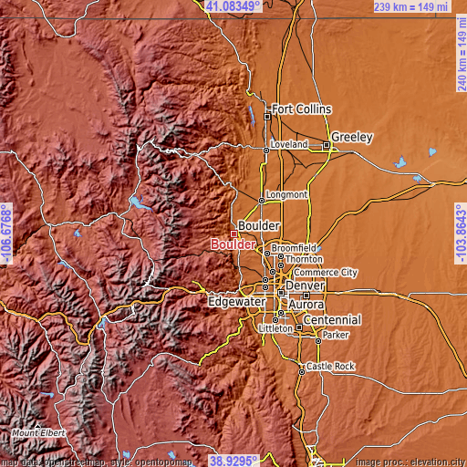
| \ | Map #1 | Map #2 | Topo.Map |
| Scale [m] | 1579..2462 m | 1557..2581 m | × |
| Scale [ft] | 5180..8077 ft | 5108..8468 ft | × |
| Average | 1729 m = 5673 ft | 1815.9 m = 5958 ft | × |
| Width | 7.48 km = 4.6 mi | 14.97 km = 9.3 mi | 239.5 km = 148.8 mi |
| Height | 7.48 km = 4.6 mi | 14.97 km = 9.3 mi | 239.5 km = 148.8 mi |
| ↑Max Latitude | 40.048638° | 40.08227° | 41.08349° |
| Latitude at center | 40.01499° | 40.01499° | 40.01499° |
| ↓Min Latitude | 39.981325° | 39.947643° | 38.9295° |
| ← Min Longitude | -105.314495° | -105.358441° | -106.6768° |
| Longitude center | -105.27055° | -105.27055° | -105.27055° |
| →Max Longitude | -105.226605° | -105.182659° | -103.8643° |
Nearby cities:
Cities around Boulder sort by population:
• Longmont elevation 1520 m
22.2 km,  40°
40°
• Broomfield 1649 m
18.9 km,  123°
123°
• Lafayette 1593 m
15.6 km,  98°
98°
• Erie 1539 m
19.2 km,  78°
78°
• Louisville 1631 m
12.5 km,  109°
109°
• Superior 1679 m
11.1 km,  128°
128°
• Gunbarrel 1616 m
10 km,  57°
57°
• Shaw Heights 1665 m
26.5 km, 132°
• Niwot 1558 m
13 km, 40°
• Coal Creek 2631 m
15.1 km,  217°
217°
• Lyons 1643 m
23.3 km,  359°
359°
• Nederland 2517 m
21.3 km,  253°
253°
Multilingual:
 En español:
Boulder elevación 1630 m.
 En France:
Boulder élévation 1630 m.
 Auf Deutsch:
Boulder höhe über dem Meeresspiegel ist 1630 m.

Sources and notes:
- [note 1] Map square and city borders are not equal. Map elevation data is calculated only from area inside that square.
- [src 1] Elevation data from geonames database provided with same terms of usage.
- [src 2] The elevation map of Boulder is generated using elevation data from NASA's 3 arcsec (90m) resolution SRTM data.
- [src 3] Base (background) map © OpenStreetMap contributors tiles are generated by Geofabrik and OpenTopoMap.
Copyright & License:
This Boulder Elevation Map is licensed under CC BY-SA. You may reuse any part from this page, if you give a proper credit by linking to this URL:
 More info on terms of use page.