Coal Creek elevation
Coal Creek (Colorado, Boulder County), United States elevation is 2631 meters and Coal Creek elevation in feet is 8632 ft above sea level [src 1]. Coal Creek is a populated place (feature code) with elevation that is 2352 meters (7717 ft) bigger than average city elevation in United States.
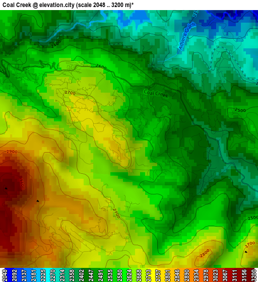
Below is the Elevation map of Coal Creek, which displays elevation range with different colors. Scale of the first map is from 2048 to 3200 m (6719 to 10499 ft) with average elevation of 2578.9 meters (=8461 ft) [note 1]
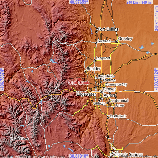
These maps also provides idea of topography and contour of this city, they are displayed at different zoom levels. More info about maps, scale and edge coordinates you can find below images.
| \ | Map #1 | Topo.Map |
| Scale [m] | 2048..3200 m | × |
| Scale [ft] | 6719..10499 ft | × |
| Average | 2578.9 m = 8461 ft | × |
| Width | 7.5 km = 4.7 mi | 239.9 km = 149.1 mi |
| Height | 7.5 km = 4.7 mi | 239.9 km = 149.1 mi |
| ↑Max Latitude | 39.940082° | 40.97659° |
| Latitude at center | 39.90638° | 39.90638° |
| ↓Min Latitude | 39.872662° | 38.81918° |
| ← Min Longitude | -105.421435° | -106.78374° |
| Longitude center | -105.37749° | -105.37749° |
| →Max Longitude | -105.333545° | -103.97124° |
Nearby cities:
Cities around Coal Creek sort by population:
• Boulder elevation 1630 m
15.1 km,  37°
37°
• Broomfield 1649 m
24.9 km,  86°
86°
• Louisville 1631 m
22.4 km,  69°
69°
• Golden 1733 m
21.4 km,  141°
141°
• Superior 1679 m
18.5 km, 73°
• Gunbarrel 1616 m
24.8 km,  45°
45°
• Applewood 1707 m
24.7 km,  131°
131°
• West Pleasant View 1775 m
25.7 km, 138°
• Genesee 2336 m
26.1 km,  159°
159°
• Idaho Springs 2300 m
21.6 km,  212°
212°
• Nederland 2517 m
12.9 km,  298°
298°
• Central City 2596 m
16.5 km,  225°
225°
Multilingual:
 En español:
Coal Creek elevación 2631 m.
 En France:
Coal Creek élévation 2631 m.
 Auf Deutsch:
Coal Creek höhe über dem Meeresspiegel ist 2631 m.

Sources and notes:
- [note 1] Map square and city borders are not equal. Map elevation data is calculated only from area inside that square.
- [src 1] Elevation data from geonames database provided with same terms of usage.
- [src 2] The elevation map of Coal Creek is generated using elevation data from NASA's 3 arcsec (90m) resolution SRTM data.
- [src 3] Base (background) map © OpenStreetMap contributors tiles are generated by Geofabrik and OpenTopoMap.
Copyright & License:
This Coal Creek Elevation Map is licensed under CC BY-SA. You may reuse any part from this page, if you give a proper credit by linking to this URL:
 More info on terms of use page.