Georgetown elevation
Georgetown (Colorado, Clear Creek County), United States elevation is 2603 meters and Georgetown elevation in feet is 8540 ft above sea level [src 1]. Georgetown is a seat of a second-order administrative division (feature code) with elevation that is 2324 meters (7625 ft) bigger than average city elevation in United States.
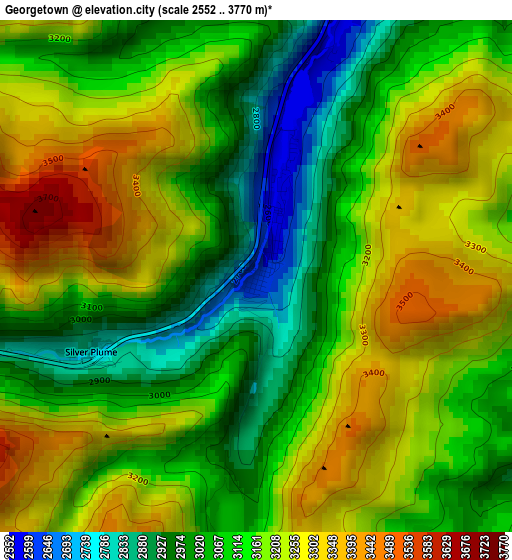
Below is the Elevation map of Georgetown, which displays elevation range with different colors. Scale of the first map is from 2552 to 3770 m (8373 to 12369 ft) with average elevation of 3149.9 meters (=10334 ft) [note 1]
These maps also provides idea of topography and contour of this city, they are displayed at different zoom levels. More info about maps, scale and edge coordinates you can find below images.
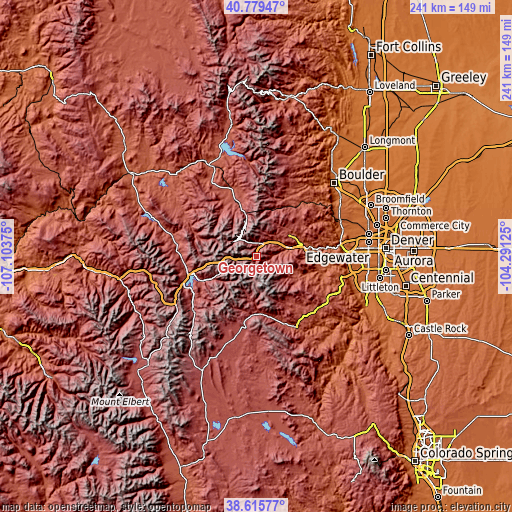
| \ | Map #1 | Topo.Map |
| Scale [m] | 2552..3770 m | × |
| Scale [ft] | 8373..12369 ft | × |
| Average | 3149.9 m = 10334 ft | × |
| Width | 7.52 km = 4.7 mi | 240.6 km = 149.5 mi |
| Height | 7.52 km = 4.7 mi | 240.6 km = 149.5 mi |
| ↑Max Latitude | 39.7399° | 40.77947° |
| Latitude at center | 39.7061° | 39.7061° |
| ↓Min Latitude | 39.672283° | 38.61577° |
| ← Min Longitude | -105.741445° | -107.10375° |
| Longitude center | -105.6975° | -105.6975° |
| →Max Longitude | -105.653555° | -104.29125° |
Nearby cities:
Cities around Georgetown sort by population:
• Evergreen elevation 2155 m
33.5 km,  103°
103°
• Silverthorne 2669 m
33.3 km,  255°
255°
• Genesee 2336 m
36.4 km,  93°
93°
• Frisco 2770 m
37.2 km,  246°
246°
• Coal Creek 2631 m
35.3 km,  50°
50°
• Idaho Springs 2300 m
16.2 km,  75°
75°
• Nederland 2517 m
32.6 km,  29°
29°
• Kittredge 2102 m
34.5 km, 99°
• Fraser 2619 m
28.5 km,  338°
338°
• Keystone 2798 m
27.5 km,  244°
244°
• Upper Bear Creek 2360 m
25.6 km,  110°
110°
• Central City 2596 m
19 km,  55°
55°
Multilingual:
 En español:
Georgetown elevación 2603 m.
 En France:
Georgetown élévation 2603 m.
 Auf Deutsch:
Georgetown höhe über dem Meeresspiegel ist 2603 m.

Sources and notes:
- [note 1] Map square and city borders are not equal. Map elevation data is calculated only from area inside that square.
- [src 1] Elevation data from geonames database provided with same terms of usage.
- [src 2] The elevation map of Georgetown is generated using elevation data from NASA's 3 arcsec (90m) resolution SRTM data.
- [src 3] Base (background) map © OpenStreetMap contributors tiles are generated by Geofabrik and OpenTopoMap.
Copyright & License:
This Georgetown Elevation Map is licensed under CC BY-SA. You may reuse any part from this page, if you give a proper credit by linking to this URL:
 More info on terms of use page.