Steamboat Springs elevation
Steamboat Springs (Colorado, Routt County), United States elevation is 2058 meters and Steamboat Springs elevation in feet is 6752 ft above sea level [src 1]. Steamboat Springs is a seat of a second-order administrative division (feature code) with elevation that is 1779 meters (5837 ft) bigger than average city elevation in United States.
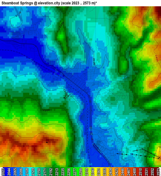
Below is the Elevation map of Steamboat Springs, which displays elevation range with different colors. Scale of the first map is from 2023 to 2573 m (6637 to 8442 ft) with average elevation of 2187.7 meters (=7177 ft) [note 1]
These maps also provides idea of topography and contour of this city, they are displayed at different zoom levels. More info about maps, scale and edge coordinates you can find below images.
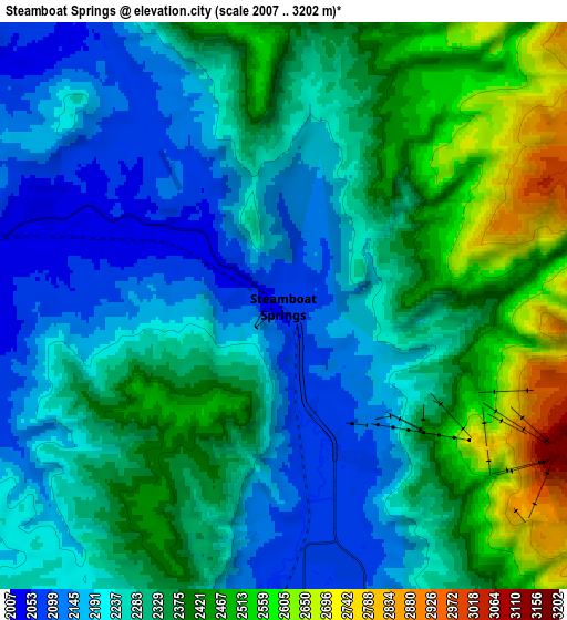
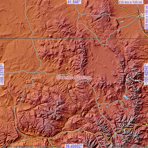
| \ | Map #1 | Map #2 | Topo.Map |
| Scale [m] | 2023..2573 m | 2007..3202 m | × |
| Scale [ft] | 6637..8442 ft | 6585..10505 ft | × |
| Average | 2187.7 m = 7177 ft | 2306.1 m = 7566 ft | × |
| Width | 7.43 km = 4.6 mi | 14.87 km = 9.2 mi | 237.8 km = 147.8 mi |
| Height | 7.43 km = 4.6 mi | 14.87 km = 9.2 mi | 237.8 km = 147.8 mi |
| ↑Max Latitude | 40.518395° | 40.551794° | 41.546° |
| Latitude at center | 40.48498° | 40.48498° | 40.48498° |
| ↓Min Latitude | 40.451548° | 40.418099° | 39.40692° |
| ← Min Longitude | -106.875665° | -106.919611° | -108.23797° |
| Longitude center | -106.83172° | -106.83172° | -106.83172° |
| →Max Longitude | -106.787775° | -106.743829° | -105.42547° |
Nearby cities:
Cities around Steamboat Springs sort by population:
• Edwards elevation 2205 m
95.6 km,  167°
167°
• Craig 1891 m
60.5 km,  273°
273°
• Gypsum 1929 m
93.7 km,  186°
186°
• Eagle 2020 m
92.3 km,  179°
179°
• Avon 2270 m
98.5 km,  164°
164°
• Vail 2501 m
101.7 km, 157°
• Meeker 1907 m
104.4 km,  241°
241°
• Granby 2434 m
87.7 km,  120°
120°
• Hayden 1937 m
36 km, 271°
• Kremmling 2250 m
60.5 km,  141°
141°
• Hot Sulphur Springs 2361 m
76.9 km,  126°
126°
• Walden 2472 m
53.8 km,  59°
59°
Multilingual:
 En español:
Steamboat Springs elevación 2058 m.
 En France:
Steamboat Springs élévation 2058 m.
 Auf Deutsch:
Steamboat Springs höhe über dem Meeresspiegel ist 2058 m.

Sources and notes:
- [note 1] Map square and city borders are not equal. Map elevation data is calculated only from area inside that square.
- [src 1] Elevation data from geonames database provided with same terms of usage.
- [src 2] The elevation map of Steamboat Springs is generated using elevation data from NASA's 3 arcsec (90m) resolution SRTM data.
- [src 3] Base (background) map © OpenStreetMap contributors tiles are generated by Geofabrik and OpenTopoMap.
Copyright & License:
This Steamboat Springs Elevation Map is licensed under CC BY-SA. You may reuse any part from this page, if you give a proper credit by linking to this URL:
 More info on terms of use page.