Vail elevation
Vail (Colorado, Eagle County), United States elevation is 2501 meters and Vail elevation in feet is 8205 ft above sea level [src 1]. Vail is a populated place (feature code) with elevation that is 2222 meters (7290 ft) bigger than average city elevation in United States.
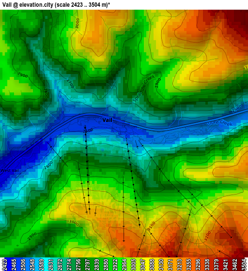
Below is the Elevation map of Vail, which displays elevation range with different colors. Scale of the first map is from 2423 to 3504 m (7949 to 11496 ft) with average elevation of 2891.7 meters (=9487 ft) [note 1]
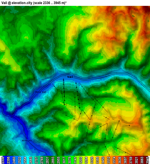
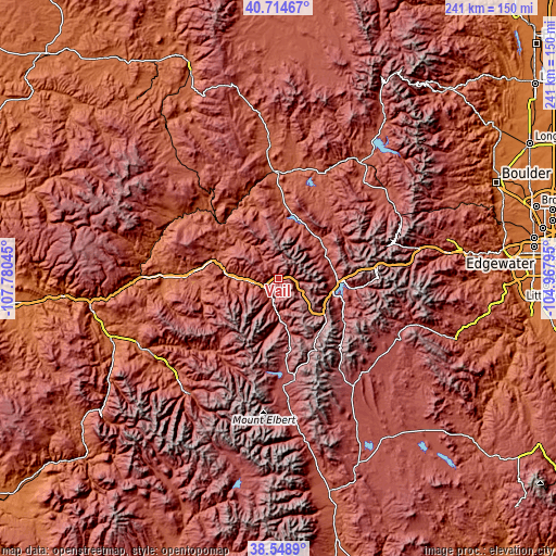
These maps also provides idea of topography and contour of this city, they are displayed at different zoom levels. More info about maps, scale and edge coordinates you can find below images.
| \ | Map #1 | Map #2 | Topo.Map |
| Scale [m] | 2423..3504 m | 2336..3945 m | × |
| Scale [ft] | 7949..11496 ft | 7664..12943 ft | × |
| Average | 2891.7 m = 9487 ft | 2997.9 m = 9836 ft | × |
| Width | 7.53 km = 4.7 mi | 15.05 km = 9.4 mi | 240.8 km = 149.6 mi |
| Height | 7.53 km = 4.7 mi | 15.05 km = 9.4 mi | 240.8 km = 149.6 mi |
| ↑Max Latitude | 39.674092° | 39.707908° | 40.71467° |
| Latitude at center | 39.64026° | 39.64026° | 39.64026° |
| ↓Min Latitude | 39.606411° | 39.572545° | 38.5489° |
| ← Min Longitude | -106.418145° | -106.462091° | -107.78045° |
| Longitude center | -106.3742° | -106.3742° | -106.3742° |
| →Max Longitude | -106.330255° | -106.286309° | -104.96795° |
Nearby cities:
Cities around Vail sort by population:
• Edwards elevation 2205 m
18.8 km,  271°
271°
• Gypsum 1929 m
49.5 km, 270°
• Eagle 2020 m
38.9 km, 272°
• Avon 2270 m
12.7 km, 265°
• Breckenridge 2976 m
33.8 km,  121°
121°
• Silverthorne 2669 m
25.7 km,  92°
92°
• Frisco 2770 m
24.8 km,  107°
107°
• Leadville 3103 m
43.9 km,  170°
170°
• Leadville North 3079 m
43 km, 171°
• Kremmling 2250 m
46.6 km,  358°
358°
• Keystone 2798 m
33.5 km,  97°
97°
• Minturn 2398 m
7.7 km,  219°
219°
Multilingual:
 En español:
Vail elevación 2501 m.
 En France:
Vail élévation 2501 m.


Sources and notes:
- [note 1] Map square and city borders are not equal. Map elevation data is calculated only from area inside that square.
- [src 1] Elevation data from geonames database provided with same terms of usage.
- [src 2] The elevation map of Vail is generated using elevation data from NASA's 3 arcsec (90m) resolution SRTM data.
- [src 3] Base (background) map © OpenStreetMap contributors tiles are generated by Geofabrik and OpenTopoMap.
Copyright & License:
This Vail Elevation Map is licensed under CC BY-SA. You may reuse any part from this page, if you give a proper credit by linking to this URL:
 More info on terms of use page.