Rock Springs elevation
Rock Springs (Wyoming, Sweetwater County), United States elevation is 1954 meters and Rock Springs elevation in feet is 6411 ft above sea level [src 1]. Rock Springs is a populated place (feature code) with elevation that is 1675 meters (5495 ft) bigger than average city elevation in United States.
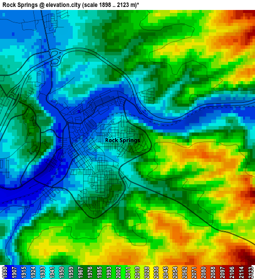
Below is the Elevation map of Rock Springs, which displays elevation range with different colors. Scale of the first map is from 1898 to 2123 m (6227 to 6965 ft) with average elevation of 1975.2 meters (=6480 ft) [note 1]
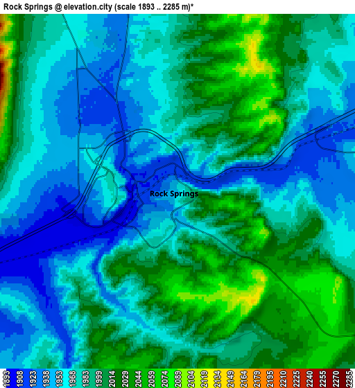
These maps also provides idea of topography and contour of this city, they are displayed at different zoom levels. More info about maps, scale and edge coordinates you can find below images.
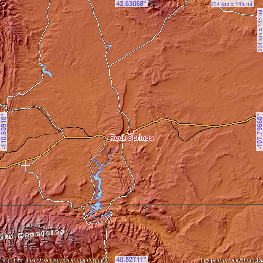
| \ | Map #1 | Map #2 | Topo.Map |
| Scale [m] | 1898..2123 m | 1893..2285 m | × |
| Scale [ft] | 6227..6965 ft | 6211..7497 ft | × |
| Average | 1975.2 m = 6480 ft | 1983.6 m = 6508 ft | × |
| Width | 7.31 km = 4.5 mi | 14.62 km = 9.1 mi | 233.9 km = 145.3 mi |
| Height | 7.31 km = 4.5 mi | 14.62 km = 9.1 mi | 233.9 km = 145.3 mi |
| ↑Max Latitude | 41.62032° | 41.653164° | 42.63068° |
| Latitude at center | 41.58746° | 41.58746° | 41.58746° |
| ↓Min Latitude | 41.554583° | 41.521689° | 40.52711° |
| ← Min Longitude | -109.246845° | -109.290791° | -110.60915° |
| Longitude center | -109.2029° | -109.2029° | -109.2029° |
| →Max Longitude | -109.158955° | -109.115009° | -107.79665° |
Nearby cities:
Cities around Rock Springs sort by population:
• Green River elevation 1865 m
22.9 km,  253°
253°
• Evanston 2060 m
151 km,  256°
256°
• Vernal 1628 m
128.8 km,  192°
192°
• Lander 1637 m
143.8 km,  15°
15°
• Maeser 1711 m
127.6 km, 194°
• Kemmerer 2121 m
113.1 km,  281°
281°
• Naples 1597 m
131.4 km, 190°
• North Rock Springs 1978 m
8.1 km,  320°
320°
• Lyman 2048 m
95.3 km, 252°
• Mountain View 2080 m
101.2 km, 249°
• Marbleton 2095 m
130.9 km,  325°
325°
• Manila 1938 m
79.5 km,  213°
213°
Multilingual:
 En español:
Rock Springs elevación 1954 m.
 En France:
Rock Springs élévation 1954 m.
 Auf Deutsch:
Rock Springs höhe über dem Meeresspiegel ist 1954 m.

Sources and notes:
- [note 1] Map square and city borders are not equal. Map elevation data is calculated only from area inside that square.
- [src 1] Elevation data from geonames database provided with same terms of usage.
- [src 2] The elevation map of Rock Springs is generated using elevation data from NASA's 3 arcsec (90m) resolution SRTM data.
- [src 3] Base (background) map © OpenStreetMap contributors tiles are generated by Geofabrik and OpenTopoMap.
Copyright & License:
This Rock Springs Elevation Map is licensed under CC BY-SA. You may reuse any part from this page, if you give a proper credit by linking to this URL:
 More info on terms of use page.