Marbleton elevation
Marbleton (Wyoming, Sublette County), United States elevation is 2095 meters and Marbleton elevation in feet is 6873 ft above sea level [src 1]. Marbleton is a populated place (feature code) with elevation that is 1816 meters (5958 ft) bigger than average city elevation in United States.
Below is the Elevation map of Marbleton, which displays elevation range with different colors. Scale of the first map is from 2054 to 2162 m (6739 to 7093 ft) with average elevation of 2094.9 meters (=6873 ft) [note 1]
These maps also provides idea of topography and contour of this city, they are displayed at different zoom levels. More info about maps, scale and edge coordinates you can find below images.
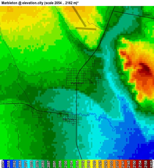
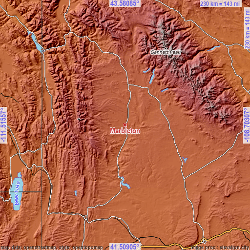
| \ | Map #1 | Topo.Map |
| Scale [m] | 2054..2162 m | × |
| Scale [ft] | 6739..7093 ft | × |
| Average | 2094.9 m = 6873 ft | × |
| Width | 7.2 km = 4.5 mi | 230.4 km = 143.2 mi |
| Height | 7.2 km = 4.5 mi | 230.4 km = 143.2 mi |
| ↑Max Latitude | 42.585914° | 43.58085° |
| Latitude at center | 42.55355° | 42.55355° |
| ↓Min Latitude | 42.521169° | 41.50905° |
| ← Min Longitude | -110.153265° | -111.51557° |
| Longitude center | -110.10932° | -110.10932° |
| →Max Longitude | -110.065375° | -108.70307° |
Nearby cities:
Cities around Marbleton sort by population:
• Jackson elevation 1904 m
115.9 km,  332°
332°
• Lander 1637 m
116.9 km,  74°
74°
• Kemmerer 2121 m
91.7 km,  202°
202°
• Montpelier 1828 m
100.9 km,  255°
255°
• Afton 1906 m
69.9 km,  285°
285°
• Pinedale 2190 m
40.3 km,  30°
30°
• Fort Washakie 1696 m
112.1 km,  63°
63°
• South Park 1846 m
111.5 km, 330°
• Star Valley Ranch 1910 m
83.2 km,  303°
303°
• Hoback 1788 m
97.8 km, 325°
• Rafter J Ranch 1848 m
112.1 km, 329°
• Paris 1821 m
112.1 km,  251°
251°
Multilingual:
 En español:
Marbleton elevación 2095 m.
 En France:
Marbleton élévation 2095 m.
 Auf Deutsch:
Marbleton höhe über dem Meeresspiegel ist 2095 m.

Sources and notes:
- [note 1] Map square and city borders are not equal. Map elevation data is calculated only from area inside that square.
- [src 1] Elevation data from geonames database provided with same terms of usage.
- [src 2] The elevation map of Marbleton is generated using elevation data from NASA's 3 arcsec (90m) resolution SRTM data.
- [src 3] Base (background) map © OpenStreetMap contributors tiles are generated by Geofabrik and OpenTopoMap.
Copyright & License:
This Marbleton Elevation Map is licensed under CC BY-SA. You may reuse any part from this page, if you give a proper credit by linking to this URL:
 More info on terms of use page.