Afton elevation
Afton (Wyoming, Lincoln County), United States elevation is 1906 meters and Afton elevation in feet is 6253 ft above sea level [src 1]. Afton is a populated place (feature code) with elevation that is 1627 meters (5338 ft) bigger than average city elevation in United States.
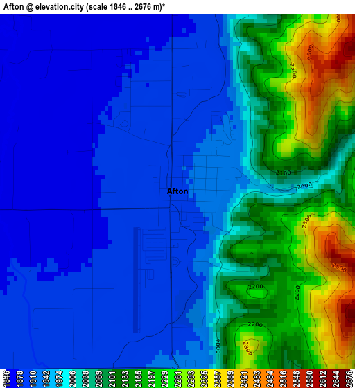
Below is the Elevation map of Afton, which displays elevation range with different colors. Scale of the first map is from 1846 to 2676 m (6056 to 8780 ft) with average elevation of 2006.4 meters (=6583 ft) [note 1]
These maps also provides idea of topography and contour of this city, they are displayed at different zoom levels. More info about maps, scale and edge coordinates you can find below images.
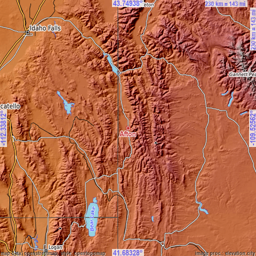
| \ | Map #1 | Topo.Map |
| Scale [m] | 1846..2676 m | × |
| Scale [ft] | 6056..8780 ft | × |
| Average | 2006.4 m = 6583 ft | × |
| Width | 7.18 km = 4.5 mi | 229.7 km = 142.7 mi |
| Height | 7.18 km = 4.5 mi | 229.7 km = 142.7 mi |
| ↑Max Latitude | 42.757205° | 43.74938° |
| Latitude at center | 42.72493° | 42.72493° |
| ↓Min Latitude | 42.692639° | 41.68328° |
| ← Min Longitude | -110.975815° | -112.33812° |
| Longitude center | -110.93187° | -110.93187° |
| →Max Longitude | -110.887925° | -109.52562° |
Nearby cities:
Cities around Afton sort by population:
• Jackson elevation 1904 m
85.1 km,  9°
9°
• Soda Springs 1762 m
55.5 km,  261°
261°
• Montpelier 1828 m
53.9 km,  213°
213°
• Pinedale 2190 m
88.8 km,  79°
79°
• Moose Wilson Road 1887 m
89.3 km,  4°
4°
• South Park 1846 m
78.3 km, 8°
• Star Valley Ranch 1910 m
27.5 km,  355°
355°
• Wilson 1876 m
86.4 km, 3°
• Hoback 1788 m
63.1 km, 11°
• Marbleton 2095 m
69.9 km,  105°
105°
• Rafter J Ranch 1848 m
78.7 km, 7°
• Paris 1821 m
67.4 km, 214°
Multilingual:
 En español:
Afton elevación 1906 m.
 En France:
Afton élévation 1906 m.


Sources and notes:
- [note 1] Map square and city borders are not equal. Map elevation data is calculated only from area inside that square.
- [src 1] Elevation data from geonames database provided with same terms of usage.
- [src 2] The elevation map of Afton is generated using elevation data from NASA's 3 arcsec (90m) resolution SRTM data.
- [src 3] Base (background) map © OpenStreetMap contributors tiles are generated by Geofabrik and OpenTopoMap.
Copyright & License:
This Afton Elevation Map is licensed under CC BY-SA. You may reuse any part from this page, if you give a proper credit by linking to this URL:
 More info on terms of use page.