South Park elevation
South Park (Wyoming, Teton County), United States elevation is 1846 meters and South Park elevation in feet is 6056 ft above sea level [src 1]. South Park is a populated place (feature code) with elevation that is 1567 meters (5141 ft) bigger than average city elevation in United States.
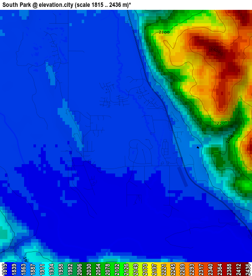
Below is the Elevation map of South Park, which displays elevation range with different colors. Scale of the first map is from 1815 to 2436 m (5955 to 7992 ft) with average elevation of 1917 meters (=6289 ft) [note 1]
These maps also provides idea of topography and contour of this city, they are displayed at different zoom levels. More info about maps, scale and edge coordinates you can find below images.
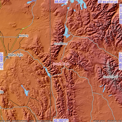
| \ | Map #1 | Topo.Map |
| Scale [m] | 1815..2436 m | × |
| Scale [ft] | 5955..7992 ft | × |
| Average | 1917 m = 6289 ft | × |
| Width | 7.1 km = 4.4 mi | 227.1 km = 141.1 mi |
| Height | 7.1 km = 4.4 mi | 227.1 km = 141.1 mi |
| ↑Max Latitude | 43.454059° | 44.4349° |
| Latitude at center | 43.42215° | 43.42215° |
| ↓Min Latitude | 43.390224° | 42.39217° |
| ← Min Longitude | -110.837205° | -112.19951° |
| Longitude center | -110.79326° | -110.79326° |
| →Max Longitude | -110.749315° | -109.38701° |
Nearby cities:
Cities around South Park sort by population:
• Rexburg elevation 1485 m
91.9 km,  299°
299°
• Jackson 1904 m
6.9 km,  21°
21°
• Afton 1906 m
78.3 km,  188°
188°
• Victor 1895 m
32.6 km,  308°
308°
• Moose Wilson Road 1887 m
12.2 km,  340°
340°
• Driggs 1863 m
42.2 km,  322°
322°
• Star Valley Ranch 1910 m
51.8 km, 194°
• Wilson 1876 m
11 km, 322°
• Sugar City 1494 m
91.7 km, 303°
• Hoback 1788 m
15.6 km,  177°
177°
• Rafter J Ranch 1848 m
0.6 km, 312°
• Ashton 1604 m
89.3 km, 323°
Multilingual:
 En español:
South Park elevación 1846 m.
 En France:
South Park élévation 1846 m.
 Auf Deutsch:
South Park höhe über dem Meeresspiegel ist 1846 m.

Sources and notes:
- [note 1] Map square and city borders are not equal. Map elevation data is calculated only from area inside that square.
- [src 1] Elevation data from geonames database provided with same terms of usage.
- [src 2] The elevation map of South Park is generated using elevation data from NASA's 3 arcsec (90m) resolution SRTM data.
- [src 3] Base (background) map © OpenStreetMap contributors tiles are generated by Geofabrik and OpenTopoMap.
Copyright & License:
This South Park Elevation Map is licensed under CC BY-SA. You may reuse any part from this page, if you give a proper credit by linking to this URL:
 More info on terms of use page.