Rushville elevation
Rushville (Nebraska, Sheridan County), United States elevation is 1140 meters and Rushville elevation in feet is 3740 ft above sea level [src 1]. Rushville is a seat of a second-order administrative division (feature code) with elevation that is 861 meters (2825 ft) bigger than average city elevation in United States.
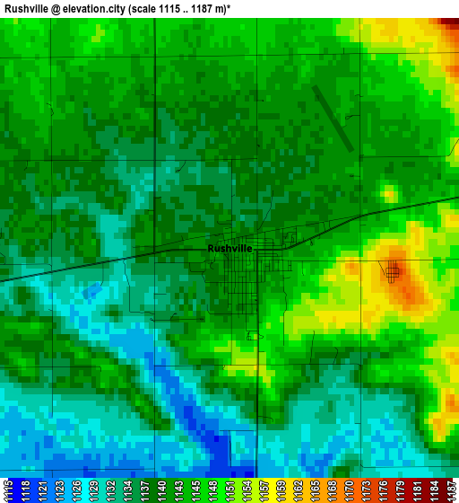
Below is the Elevation map of Rushville, which displays elevation range with different colors. Scale of the first map is from 1115 to 1187 m (3658 to 3894 ft) with average elevation of 1140.1 meters (=3740 ft) [note 1]
These maps also provides idea of topography and contour of this city, they are displayed at different zoom levels. More info about maps, scale and edge coordinates you can find below images.
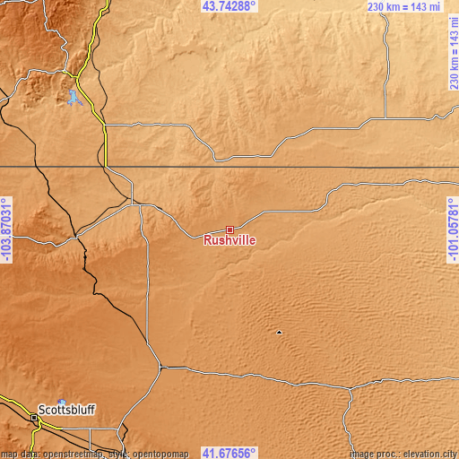
| \ | Map #1 | Topo.Map |
| Scale [m] | 1115..1187 m | × |
| Scale [ft] | 3658..3894 ft | × |
| Average | 1140.1 m = 3740 ft | × |
| Width | 7.18 km = 4.5 mi | 229.8 km = 142.8 mi |
| Height | 7.18 km = 4.5 mi | 229.7 km = 142.7 mi |
| ↑Max Latitude | 42.750598° | 43.74288° |
| Latitude at center | 42.71832° | 42.71832° |
| ↓Min Latitude | 42.686025° | 41.67656° |
| ← Min Longitude | -102.508005° | -103.87031° |
| Longitude center | -102.46406° | -102.46406° |
| →Max Longitude | -102.420115° | -101.05781° |
Nearby cities:
Cities around Rushville sort by population:
• Alliance elevation 1214 m
76.3 km,  206°
206°
• Chadron 1033 m
45.4 km,  285°
285°
• Hot Springs 1053 m
114.1 km,  314°
314°
• Pine Ridge 986 m
35 km,  347°
347°
• Gordon 1084 m
23.4 km,  65°
65°
• Bridgeport 1121 m
128.2 km,  204°
204°
• Oglala 911 m
56.9 km,  336°
336°
• Bayard 1148 m
128.4 km, 213°
• Porcupine 971 m
59 km,  10°
10°
• Martin 1008 m
78.1 km,  49°
49°
• Harrison 1485 m
116 km,  268°
268°
• Hyannis 1144 m
98.5 km,  144°
144°
Multilingual:
 En español:
Rushville elevación 1140 m.
 En France:
Rushville élévation 1140 m.
 Auf Deutsch:
Rushville höhe über dem Meeresspiegel ist 1140 m.

Sources and notes:
- [note 1] Map square and city borders are not equal. Map elevation data is calculated only from area inside that square.
- [src 1] Elevation data from geonames database provided with same terms of usage.
- [src 2] The elevation map of Rushville is generated using elevation data from NASA's 3 arcsec (90m) resolution SRTM data.
- [src 3] Base (background) map © OpenStreetMap contributors tiles are generated by Geofabrik and OpenTopoMap.
Copyright & License:
This Rushville Elevation Map is licensed under CC BY-SA. You may reuse any part from this page, if you give a proper credit by linking to this URL:
 More info on terms of use page.