Hot Springs elevation
Hot Springs (South Dakota, Fall River County), United States elevation is 1053 meters and Hot Springs elevation in feet is 3455 ft above sea level [src 1]. Hot Springs is a seat of a second-order administrative division (feature code) with elevation that is 774 meters (2539 ft) bigger than average city elevation in United States.
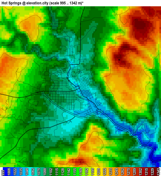
Below is the Elevation map of Hot Springs, which displays elevation range with different colors. Scale of the first map is from 995 to 1342 m (3264 to 4403 ft) with average elevation of 1147.4 meters (=3764 ft) [note 1]
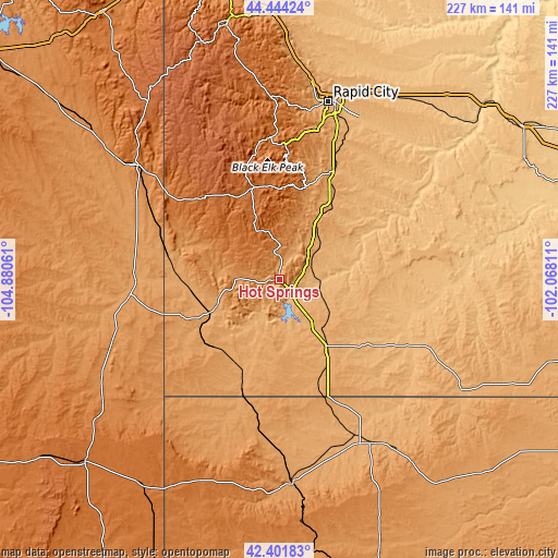
These maps also provides idea of topography and contour of this city, they are displayed at different zoom levels. More info about maps, scale and edge coordinates you can find below images.
| \ | Map #1 | Map #2 | Topo.Map |
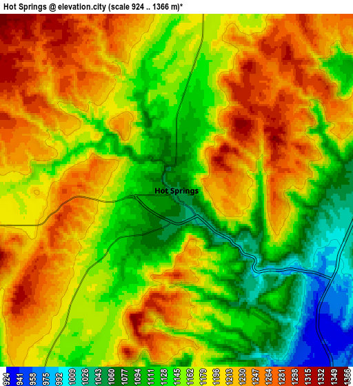
| Scale [m] | 995..1342 m | 924..1366 m | × |
| Scale [ft] | 3264..4403 ft | 3031..4482 ft | × |
| Average | 1147.4 m = 3764 ft | 1172.8 m = 3848 ft | × |
| Width | 7.1 km = 4.4 mi | 14.19 km = 8.8 mi | 227.1 km = 141.1 mi |
| Height | 7.1 km = 4.4 mi | 14.19 km = 8.8 mi | 227.1 km = 141.1 mi |
| ↑Max Latitude | 43.463554° | 43.495442° | 44.44424° |
| Latitude at center | 43.43165° | 43.43165° | 43.43165° |
| ↓Min Latitude | 43.399729° | 43.367791° | 42.40183° |
| ← Min Longitude | -103.518305° | -103.562251° | -104.88061° |
| Longitude center | -103.47436° | -103.47436° | -103.47436° |
| →Max Longitude | -103.430415° | -103.386469° | -102.06811° |
Nearby cities:
Cities around Hot Springs sort by population:
• Rapid City elevation 990 m
74.7 km,  15°
15°
• Box Elder 924 m
82.4 km, 23°
• Rapid Valley 961 m
74.9 km, 20°
• Chadron 1033 m
77.2 km,  150°
150°
• Newcastle 1323 m
75.3 km,  308°
308°
• Pine Ridge 986 m
87 km,  121°
121°
• Blackhawk 1064 m
81.1 km,  9°
9°
• Colonial Pine Hills 1246 m
65.3 km, 11°
• Summerset 1107 m
85 km, 7°
• Custer 1619 m
38.6 km,  344°
344°
• Oglala 911 m
65.3 km,  114°
114°
• Harrison 1485 m
89.2 km,  201°
201°
Multilingual:
 En español:
Hot Springs elevación 1053 m.
 En France:
Hot Springs élévation 1053 m.
 Auf Deutsch:
Hot Springs höhe über dem Meeresspiegel ist 1053 m.

Sources and notes:
- [note 1] Map square and city borders are not equal. Map elevation data is calculated only from area inside that square.
- [src 1] Elevation data from geonames database provided with same terms of usage.
- [src 2] The elevation map of Hot Springs is generated using elevation data from NASA's 3 arcsec (90m) resolution SRTM data.
- [src 3] Base (background) map © OpenStreetMap contributors tiles are generated by Geofabrik and OpenTopoMap.
Copyright & License:
This Hot Springs Elevation Map is licensed under CC BY-SA. You may reuse any part from this page, if you give a proper credit by linking to this URL:
 More info on terms of use page.