Oglala elevation
Oglala (South Dakota, Oglala Lakota County), United States elevation is 911 meters and Oglala elevation in feet is 2989 ft above sea level [src 1]. Oglala is a populated place (feature code) with elevation that is 632 meters (2073 ft) bigger than average city elevation in United States.
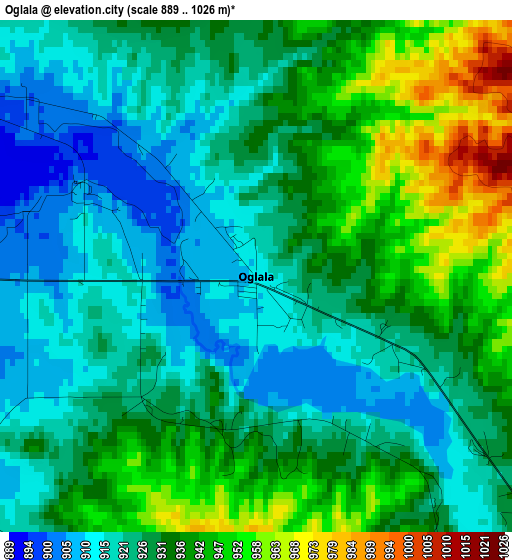
Below is the Elevation map of Oglala, which displays elevation range with different colors. Scale of the first map is from 889 to 1026 m (2917 to 3366 ft) with average elevation of 930.2 meters (=3052 ft) [note 1]
These maps also provides idea of topography and contour of this city, they are displayed at different zoom levels. More info about maps, scale and edge coordinates you can find below images.
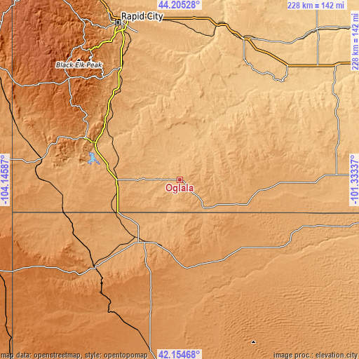
| \ | Map #1 | Topo.Map |
| Scale [m] | 889..1026 m | × |
| Scale [ft] | 2917..3366 ft | × |
| Average | 930.2 m = 3052 ft | × |
| Width | 7.13 km = 4.4 mi | 228 km = 141.7 mi |
| Height | 7.13 km = 4.4 mi | 228 km = 141.7 mi |
| ↑Max Latitude | 43.220622° | 44.20528° |
| Latitude at center | 43.18859° | 43.18859° |
| ↓Min Latitude | 43.156541° | 42.15468° |
| ← Min Longitude | -102.783565° | -104.14587° |
| Longitude center | -102.73962° | -102.73962° |
| →Max Longitude | -102.695675° | -101.33337° |
Nearby cities:
Cities around Oglala sort by population:
• Rapid City elevation 990 m
106.8 km,  338°
338°
• Box Elder 924 m
106.1 km,  345°
345°
• Rapid Valley 961 m
102.5 km, 341°
• Chadron 1033 m
45.2 km,  207°
207°
• Hot Springs 1053 m
65.3 km,  294°
294°
• Pine Ridge 986 m
23.5 km,  140°
140°
• Colonial Pine Hills 1246 m
102.2 km,  333°
333°
• Custer 1619 m
94.5 km,  312°
312°
• Gordon 1084 m
61 km,  134°
134°
• Porcupine 971 m
33.6 km,  80°
80°
• Martin 1008 m
81.7 km,  91°
91°
• Rushville 1140 m
56.9 km,  156°
156°
Multilingual:
 En español:
Oglala elevación 911 m.
 En France:
Oglala élévation 911 m.


Sources and notes:
- [note 1] Map square and city borders are not equal. Map elevation data is calculated only from area inside that square.
- [src 1] Elevation data from geonames database provided with same terms of usage.
- [src 2] The elevation map of Oglala is generated using elevation data from NASA's 3 arcsec (90m) resolution SRTM data.
- [src 3] Base (background) map © OpenStreetMap contributors tiles are generated by Geofabrik and OpenTopoMap.
Copyright & License:
This Oglala Elevation Map is licensed under CC BY-SA. You may reuse any part from this page, if you give a proper credit by linking to this URL:
 More info on terms of use page.