Gordon elevation
Gordon (Nebraska, Sheridan County), United States elevation is 1084 meters and Gordon elevation in feet is 3556 ft above sea level [src 1]. Gordon is a populated place (feature code) with elevation that is 805 meters (2641 ft) bigger than average city elevation in United States.
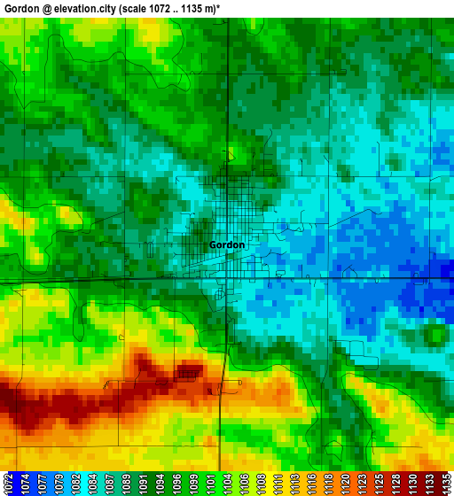
Below is the Elevation map of Gordon, which displays elevation range with different colors. Scale of the first map is from 1072 to 1135 m (3517 to 3724 ft) with average elevation of 1095.7 meters (=3595 ft) [note 1]
These maps also provides idea of topography and contour of this city, they are displayed at different zoom levels. More info about maps, scale and edge coordinates you can find below images.
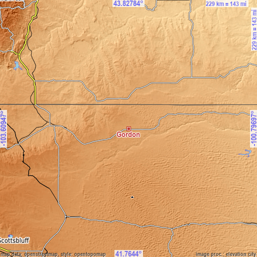
| \ | Map #1 | Topo.Map |
| Scale [m] | 1072..1135 m | × |
| Scale [ft] | 3517..3724 ft | × |
| Average | 1095.7 m = 3595 ft | × |
| Width | 7.17 km = 4.5 mi | 229.4 km = 142.5 mi |
| Height | 7.17 km = 4.5 mi | 229.4 km = 142.5 mi |
| ↑Max Latitude | 42.836953° | 43.82784° |
| Latitude at center | 42.80472° | 42.80472° |
| ↓Min Latitude | 42.77247° | 41.7644° |
| ← Min Longitude | -102.247165° | -103.60947° |
| Longitude center | -102.20322° | -102.20322° |
| →Max Longitude | -102.159275° | -100.79697° |
Nearby cities:
Cities around Gordon sort by population:
• Alliance elevation 1214 m
95.5 km,  215°
215°
• Chadron 1033 m
65 km,  272°
272°
• Hot Springs 1053 m
124.5 km,  304°
304°
• Pine Ridge 986 m
37.8 km,  310°
310°
• Rosebud 804 m
119.6 km,  66°
66°
• Oglala 911 m
61 km, 314°
• Porcupine 971 m
49.5 km,  347°
347°
• Martin 1008 m
56 km,  43°
43°
• Rushville 1140 m
23.4 km,  245°
245°
• Kadoka 751 m
127.4 km,  26°
26°
• Mullen 977 m
127.5 km,  131°
131°
• Hyannis 1144 m
96.5 km,  157°
157°
Multilingual:
 En español:
Gordon elevación 1084 m.
 En France:
Gordon élévation 1084 m.


Sources and notes:
- [note 1] Map square and city borders are not equal. Map elevation data is calculated only from area inside that square.
- [src 1] Elevation data from geonames database provided with same terms of usage.
- [src 2] The elevation map of Gordon is generated using elevation data from NASA's 3 arcsec (90m) resolution SRTM data.
- [src 3] Base (background) map © OpenStreetMap contributors tiles are generated by Geofabrik and OpenTopoMap.
Copyright & License:
This Gordon Elevation Map is licensed under CC BY-SA. You may reuse any part from this page, if you give a proper credit by linking to this URL:
 More info on terms of use page.