Winnett elevation
Winnett (Montana, Petroleum County), United States elevation is 899 meters and Winnett elevation in feet is 2949 ft above sea level [src 1]. Winnett is a seat of a second-order administrative division (feature code) with elevation that is 620 meters (2034 ft) bigger than average city elevation in United States.
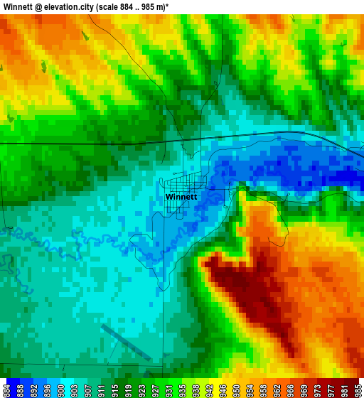
Below is the Elevation map of Winnett, which displays elevation range with different colors. Scale of the first map is from 884 to 985 m (2900 to 3232 ft) with average elevation of 925.1 meters (=3035 ft) [note 1]
These maps also provides idea of topography and contour of this city, they are displayed at different zoom levels. More info about maps, scale and edge coordinates you can find below images.
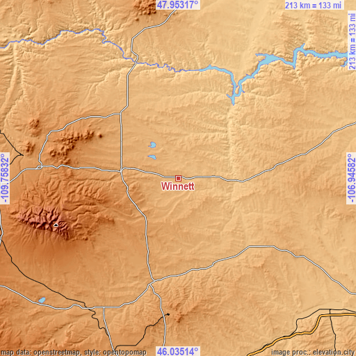
| \ | Map #1 | Topo.Map |
| Scale [m] | 884..985 m | × |
| Scale [ft] | 2900..3232 ft | × |
| Average | 925.1 m = 3035 ft | × |
| Width | 6.66 km = 4.1 mi | 213.3 km = 132.5 mi |
| Height | 6.66 km = 4.1 mi | 213.3 km = 132.5 mi |
| ↑Max Latitude | 47.032721° | 47.95317° |
| Latitude at center | 47.00276° | 47.00276° |
| ↓Min Latitude | 46.972783° | 46.03514° |
| ← Min Longitude | -108.396015° | -109.75832° |
| Longitude center | -108.35207° | -108.35207° |
| →Max Longitude | -108.308125° | -106.94582° |
Nearby cities:
Cities around Winnett sort by population:
• Billings elevation 954 m
136.1 km,  184°
184°
• Laurel 1006 m
151.7 km,  192°
192°
• Lockwood 942 m
131.7 km, 182°
• Lewistown 1202 m
81.8 km,  274°
274°
• Hardin 886 m
152.2 km,  158°
158°
• Forsyth 769 m
151.8 km,  122°
122°
• Roundup 979 m
63.7 km, 193°
• Harlowton 1281 m
129.4 km,  240°
240°
• Jordan 793 m
114.6 km,  72°
72°
• Stanford 1302 m
142.3 km,  276°
276°
• Hysham 809 m
116.2 km,  132°
132°
• Ryegate 1115 m
104.6 km,  221°
221°
Multilingual:
 En español:
Winnett elevación 899 m.
 En France:
Winnett élévation 899 m.


Sources and notes:
- [note 1] Map square and city borders are not equal. Map elevation data is calculated only from area inside that square.
- [src 1] Elevation data from geonames database provided with same terms of usage.
- [src 2] The elevation map of Winnett is generated using elevation data from NASA's 3 arcsec (90m) resolution SRTM data.
- [src 3] Base (background) map © OpenStreetMap contributors tiles are generated by Geofabrik and OpenTopoMap.
Copyright & License:
This Winnett Elevation Map is licensed under CC BY-SA. You may reuse any part from this page, if you give a proper credit by linking to this URL:
 More info on terms of use page.