Lewistown elevation
Lewistown (Montana, Fergus County), United States elevation is 1202 meters and Lewistown elevation in feet is 3944 ft above sea level [src 1]. Lewistown is a seat of a second-order administrative division (feature code) with elevation that is 923 meters (3028 ft) bigger than average city elevation in United States.
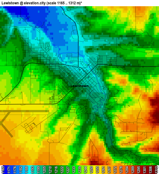
Below is the Elevation map of Lewistown, which displays elevation range with different colors. Scale of the first map is from 1165 to 1312 m (3822 to 4304 ft) with average elevation of 1229.9 meters (=4035 ft) [note 1]
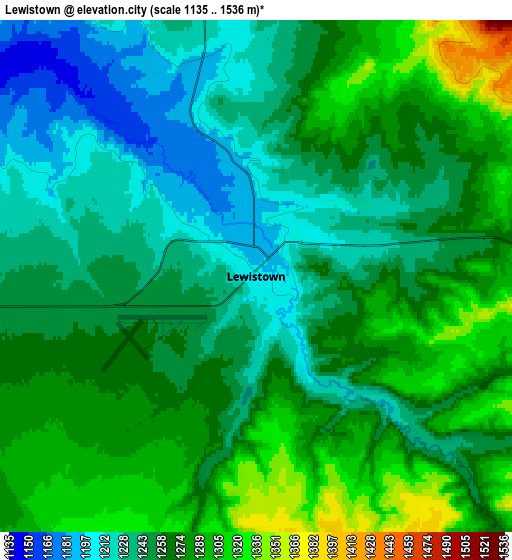
These maps also provides idea of topography and contour of this city, they are displayed at different zoom levels. More info about maps, scale and edge coordinates you can find below images.
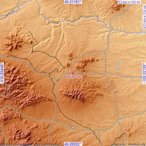
| \ | Map #1 | Map #2 | Topo.Map |
| Scale [m] | 1165..1312 m | 1135..1536 m | × |
| Scale [ft] | 3822..4304 ft | 3724..5039 ft | × |
| Average | 1229.9 m = 4035 ft | 1260 m = 4134 ft | × |
| Width | 6.66 km = 4.1 mi | 13.31 km = 8.3 mi | 213 km = 132.4 mi |
| Height | 6.66 km = 4.1 mi | 13.31 km = 8.3 mi | 213 km = 132.4 mi |
| ↑Max Latitude | 47.092397° | 47.122308° | 48.01181° |
| Latitude at center | 47.06247° | 47.06247° | 47.06247° |
| ↓Min Latitude | 47.032526° | 47.002565° | 46.09592° |
| ← Min Longitude | -109.472185° | -109.516131° | -110.83449° |
| Longitude center | -109.42824° | -109.42824° | -109.42824° |
| →Max Longitude | -109.384295° | -109.340349° | -108.02199° |
Nearby cities:
Cities around Lewistown sort by population:
• Billings elevation 954 m
159 km,  153°
153°
• Great Falls 1014 m
149.4 km,  289°
289°
• Lockwood 942 m
158.6 km, 150°
• Malmstrom Air Force Base 1056 m
141.2 km, 290°
• Roundup 979 m
96.3 km,  135°
135°
• Big Timber 1248 m
142.3 km,  196°
196°
• Fort Benton 803 m
125.5 km,  312°
312°
• Harlowton 1281 m
76.3 km, 203°
• White Sulphur Springs 1534 m
125.9 km,  242°
242°
• Stanford 1302 m
60.6 km,  279°
279°
• Ryegate 1115 m
86.1 km,  171°
171°
• Winnett 899 m
81.8 km,  94°
94°
Multilingual:
 En español:
Lewistown elevación 1202 m.
 En France:
Lewistown élévation 1202 m.
 Auf Deutsch:
Lewistown höhe über dem Meeresspiegel ist 1202 m.

Sources and notes:
- [note 1] Map square and city borders are not equal. Map elevation data is calculated only from area inside that square.
- [src 1] Elevation data from geonames database provided with same terms of usage.
- [src 2] The elevation map of Lewistown is generated using elevation data from NASA's 3 arcsec (90m) resolution SRTM data.
- [src 3] Base (background) map © OpenStreetMap contributors tiles are generated by Geofabrik and OpenTopoMap.
Copyright & License:
This Lewistown Elevation Map is licensed under CC BY-SA. You may reuse any part from this page, if you give a proper credit by linking to this URL:
 More info on terms of use page.