Stanford elevation
Stanford (Montana, Judith Basin County), United States elevation is 1302 meters and Stanford elevation in feet is 4272 ft above sea level [src 1]. Stanford is a seat of a second-order administrative division (feature code) with elevation that is 1023 meters (3356 ft) bigger than average city elevation in United States.
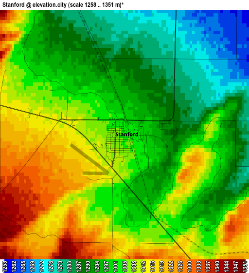
Below is the Elevation map of Stanford, which displays elevation range with different colors. Scale of the first map is from 1258 to 1351 m (4127 to 4432 ft) with average elevation of 1301.9 meters (=4271 ft) [note 1]
These maps also provides idea of topography and contour of this city, they are displayed at different zoom levels. More info about maps, scale and edge coordinates you can find below images.
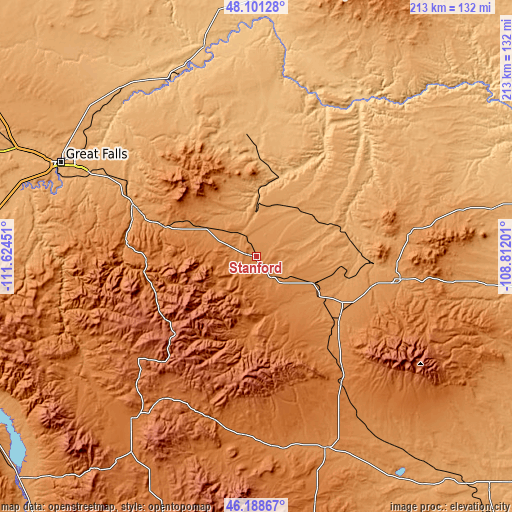
| \ | Map #1 | Topo.Map |
| Scale [m] | 1258..1351 m | × |
| Scale [ft] | 4127..4432 ft | × |
| Average | 1301.9 m = 4271 ft | × |
| Width | 6.65 km = 4.1 mi | 212.7 km = 132.2 mi |
| Height | 6.65 km = 4.1 mi | 212.6 km = 132.1 mi |
| ↑Max Latitude | 47.183456° | 48.10128° |
| Latitude at center | 47.15358° | 47.15358° |
| ↓Min Latitude | 47.123687° | 46.18867° |
| ← Min Longitude | -110.262205° | -111.62451° |
| Longitude center | -110.21826° | -110.21826° |
| →Max Longitude | -110.174315° | -108.81201° |
Nearby cities:
Cities around Stanford sort by population:
• Great Falls elevation 1014 m
90.2 km,  295°
295°
• Helena Valley Southeast 1156 m
142.6 km,  245°
245°
• Lewistown 1202 m
60.6 km,  99°
99°
• Malmstrom Air Force Base 1056 m
82.6 km, 298°
• Helena Valley Northeast 1110 m
141 km, 248°
• Townsend 1167 m
135.9 km,  226°
226°
• Sun Prairie 1016 m
104.3 km,  294°
294°
• Fort Benton 803 m
81.3 km,  335°
335°
• Harlowton 1281 m
85 km,  159°
159°
• White Sulphur Springs 1534 m
85.1 km,  217°
217°
• Ryegate 1115 m
120.1 km,  142°
142°
• Winnett 899 m
142.3 km, 96°
Multilingual:
 En español:
Stanford elevación 1302 m.
 En France:
Stanford élévation 1302 m.
 Auf Deutsch:
Stanford höhe über dem Meeresspiegel ist 1302 m.

Sources and notes:
- [note 1] Map square and city borders are not equal. Map elevation data is calculated only from area inside that square.
- [src 1] Elevation data from geonames database provided with same terms of usage.
- [src 2] The elevation map of Stanford is generated using elevation data from NASA's 3 arcsec (90m) resolution SRTM data.
- [src 3] Base (background) map © OpenStreetMap contributors tiles are generated by Geofabrik and OpenTopoMap.
Copyright & License:
This Stanford Elevation Map is licensed under CC BY-SA. You may reuse any part from this page, if you give a proper credit by linking to this URL:
 More info on terms of use page.