Jordan elevation
Jordan (Montana, Garfield County), United States elevation is 793 meters and Jordan elevation in feet is 2602 ft above sea level [src 1]. Jordan is a seat of a second-order administrative division (feature code) with elevation that is 514 meters (1686 ft) bigger than average city elevation in United States.
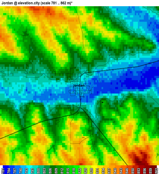
Below is the Elevation map of Jordan, which displays elevation range with different colors. Scale of the first map is from 781 to 862 m (2562 to 2828 ft) with average elevation of 813 meters (=2667 ft) [note 1]
These maps also provides idea of topography and contour of this city, they are displayed at different zoom levels. More info about maps, scale and edge coordinates you can find below images.
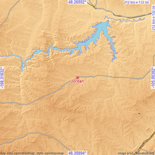
| \ | Map #1 | Topo.Map |
| Scale [m] | 781..862 m | × |
| Scale [ft] | 2562..2828 ft | × |
| Average | 813 m = 2667 ft | × |
| Width | 6.62 km = 4.1 mi | 212 km = 131.7 mi |
| Height | 6.62 km = 4.1 mi | 212 km = 131.7 mi |
| ↑Max Latitude | 47.350612° | 48.26552° |
| Latitude at center | 47.32083° | 47.32083° |
| ↓Min Latitude | 47.291031° | 46.35894° |
| ← Min Longitude | -106.954015° | -108.31632° |
| Longitude center | -106.91007° | -106.91007° |
| →Max Longitude | -106.866125° | -105.50382° |
Nearby cities:
Cities around Jordan sort by population:
• Miles City elevation 718 m
130 km,  141°
141°
• Glasgow 637 m
99.5 km,  11°
11°
• Wolf Point 609 m
127.9 km,  47°
47°
• Colstrip 986 m
161.2 km,  172°
172°
• Malta 685 m
136.1 km,  328°
328°
• West Glendive 644 m
164.8 km,  98°
98°
• Forsyth 769 m
118.6 km, 171°
• Roundup 979 m
157.7 km,  231°
231°
• Circle 744 m
99.8 km,  83°
83°
• Terry 686 m
134.5 km,  115°
115°
• Hysham 809 m
116.9 km,  192°
192°
• Winnett 899 m
114.6 km,  252°
252°
Multilingual:
 En español:
Jordan elevación 793 m.
 En France:
Jordan élévation 793 m.


Sources and notes:
- [note 1] Map square and city borders are not equal. Map elevation data is calculated only from area inside that square.
- [src 1] Elevation data from geonames database provided with same terms of usage.
- [src 2] The elevation map of Jordan is generated using elevation data from NASA's 3 arcsec (90m) resolution SRTM data.
- [src 3] Base (background) map © OpenStreetMap contributors tiles are generated by Geofabrik and OpenTopoMap.
Copyright & License:
This Jordan Elevation Map is licensed under CC BY-SA. You may reuse any part from this page, if you give a proper credit by linking to this URL:
 More info on terms of use page.