Wolf Point elevation
Wolf Point (Montana, Roosevelt County), United States elevation is 609 meters and Wolf Point elevation in feet is 1998 ft above sea level [src 1]. Wolf Point is a seat of a second-order administrative division (feature code) with elevation that is 330 meters (1083 ft) bigger than average city elevation in United States.
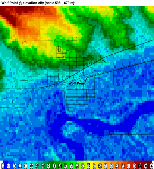
Below is the Elevation map of Wolf Point, which displays elevation range with different colors. Scale of the first map is from 596 to 679 m (1955 to 2228 ft) with average elevation of 614.9 meters (=2017 ft) [note 1]
These maps also provides idea of topography and contour of this city, they are displayed at different zoom levels. More info about maps, scale and edge coordinates you can find below images.
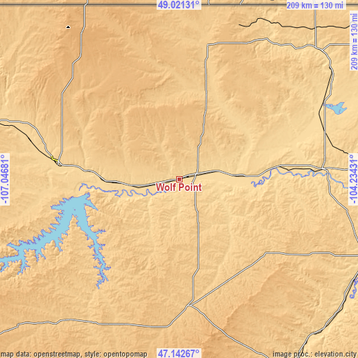
| \ | Map #1 | Topo.Map |
| Scale [m] | 596..679 m | × |
| Scale [ft] | 1955..2228 ft | × |
| Average | 614.9 m = 2017 ft | × |
| Width | 6.53 km = 4.1 mi | 208.9 km = 129.8 mi |
| Height | 6.53 km = 4.1 mi | 208.9 km = 129.8 mi |
| ↑Max Latitude | 48.119915° | 49.02131° |
| Latitude at center | 48.09057° | 48.09057° |
| ↓Min Latitude | 48.061208° | 47.14267° |
| ← Min Longitude | -105.684505° | -107.04681° |
| Longitude center | -105.64056° | -105.64056° |
| →Max Longitude | -105.596615° | -104.23431° |
Nearby cities:
Cities around Wolf Point sort by population:
• Williston elevation 573 m
150.3 km,  87°
87°
• Sidney 591 m
118.2 km,  110°
110°
• Glendive 633 m
129.8 km,  147°
147°
• Glasgow 637 m
74.8 km,  279°
279°
• Malta 685 m
168.1 km, 280°
• West Glendive 644 m
127.8 km, 148°
• Plentywood 623 m
110.1 km,  46°
46°
• Scobey 749 m
79.7 km,  11°
11°
• Wibaux 804 m
164.3 km,  138°
138°
• Circle 744 m
75 km,  177°
177°
• Terry 686 m
146.4 km,  170°
170°
• Jordan 793 m
127.9 km,  227°
227°
Multilingual:
 En español:
Wolf Point elevación 609 m.
 En France:
Wolf Point élévation 609 m.
 Auf Deutsch:
Wolf Point höhe über dem Meeresspiegel ist 609 m.

Sources and notes:
- [note 1] Map square and city borders are not equal. Map elevation data is calculated only from area inside that square.
- [src 1] Elevation data from geonames database provided with same terms of usage.
- [src 2] The elevation map of Wolf Point is generated using elevation data from NASA's 3 arcsec (90m) resolution SRTM data.
- [src 3] Base (background) map © OpenStreetMap contributors tiles are generated by Geofabrik and OpenTopoMap.
Copyright & License:
This Wolf Point Elevation Map is licensed under CC BY-SA. You may reuse any part from this page, if you give a proper credit by linking to this URL:
 More info on terms of use page.