Thompson Falls elevation
Thompson Falls (Montana, Sanders County), United States elevation is 759 meters and Thompson Falls elevation in feet is 2490 ft above sea level [src 1]. Thompson Falls is a seat of a second-order administrative division (feature code) with elevation that is 480 meters (1575 ft) bigger than average city elevation in United States.
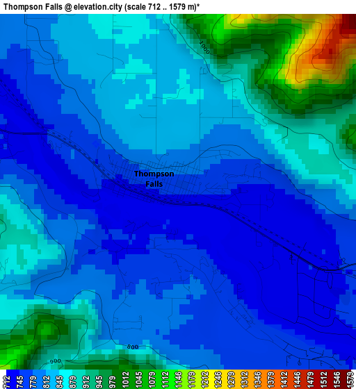
Below is the Elevation map of Thompson Falls, which displays elevation range with different colors. Scale of the first map is from 712 to 1579 m (2336 to 5180 ft) with average elevation of 833.3 meters (=2734 ft) [note 1]
These maps also provides idea of topography and contour of this city, they are displayed at different zoom levels. More info about maps, scale and edge coordinates you can find below images.
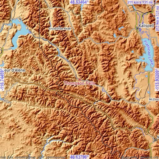
| \ | Map #1 | Topo.Map |
| Scale [m] | 712..1579 m | × |
| Scale [ft] | 2336..5180 ft | × |
| Average | 833.3 m = 2734 ft | × |
| Width | 6.59 km = 4.1 mi | 210.9 km = 131 mi |
| Height | 6.59 km = 4.1 mi | 210.9 km = 131 mi |
| ↑Max Latitude | 47.624517° | 48.53464° |
| Latitude at center | 47.59489° | 47.59489° |
| ↓Min Latitude | 47.565246° | 46.63796° |
| ← Min Longitude | -115.382285° | -116.74459° |
| Longitude center | -115.33834° | -115.33834° |
| →Max Longitude | -115.294395° | -113.93209° |
Nearby cities:
Cities around Thompson Falls sort by population:
• Polson elevation 892 m
88.7 km,  82°
82°
• Lakeside 888 m
95.6 km,  60°
60°
• Libby 640 m
89.7 km,  349°
349°
• Saint Maries 667 m
97.2 km,  251°
251°
• Pablo 939 m
91.4 km,  89°
89°
• Kellogg 703 m
58.9 km,  263°
263°
• Ronan 931 m
93.1 km, 94°
• Pinehurst 676 m
67.7 km, 264°
• Osburn 769 m
50.6 km, 258°
• Plains 754 m
37.3 km,  113°
113°
• Superior 835 m
56 km,  143°
143°
• Wallace 831 m
46.3 km, 253°
Multilingual:
 En español:
Thompson Falls elevación 759 m.
 En France:
Thompson Falls élévation 759 m.
 Auf Deutsch:
Thompson Falls höhe über dem Meeresspiegel ist 759 m.

Sources and notes:
- [note 1] Map square and city borders are not equal. Map elevation data is calculated only from area inside that square.
- [src 1] Elevation data from geonames database provided with same terms of usage.
- [src 2] The elevation map of Thompson Falls is generated using elevation data from NASA's 3 arcsec (90m) resolution SRTM data.
- [src 3] Base (background) map © OpenStreetMap contributors tiles are generated by Geofabrik and OpenTopoMap.
Copyright & License:
This Thompson Falls Elevation Map is licensed under CC BY-SA. You may reuse any part from this page, if you give a proper credit by linking to this URL:
 More info on terms of use page.